
Tags
Baltimore, bridges, engineering, Floods, HISTORY, Lake Montebello, Montebello, Public Works, water history
I was not the only one asked for information concerning Herring Run. All this info is for a walking tour on Black Friday. This instead of Mall Madness. Another submission of info:
The design for the Pedestrian Bridge at Sinclair Lane began in 2010 with final greenway plans dated on January 31, 2014. The bridge was designed by Wheeler in Bloomington, Minnesota and fabricated by Big R Bridge in Gresley, Colorado. A new pedestrian bridge was built in close proximity to Sinclair Road since the new ten foot wide greenway trail could not be accommodated using the existing Sinclair Road bridge. Also, the new pedestrian bridge location was selected to span the narrowest portion of the Herring Run Stream and the bridge length was determined to not encroach the Herring Run Stream’s 100 year flood elevation and cross over the existing DPW utility sanitary and 84” water pipes.
This info got me thinking about various reports I had read recently. Not concerning a 100 year flood, but about what would happen if the dam gave way at Montebello Lake??
August 2000 – Danger Reach Study for Lake Montebello MD Dam #107. Prepared for DPW, Bureau of Water and Wastewater. Has a lot of graphs, charts and data. ‘What if’ scenario of a dam failure at Lake Montebello, between Harford Rd and the Park. The consultants do not believe the water would go over the Harford Rd bridge, but under. They do believe it would overflow four feet above the Belair Rd bridge at Herring Run. It would overflow Manasota by two feet and Brehms lane by four feet. Sinclair Lane would be two feet under water. It would follow a path all the way to Moore’s Run. The dam is 600 feet long, 60 feet wide at top and 31 feet tall.
From the Emergency Action Plan 2016: Lake Montebello is an earthen dam built in 1880 as a water supply reservoir for the city of Baltimore. It contains approximately 410 million gallons of water, with a maximum storage of 606 million gallons. If the dam fails, this is what will be read by Emergency Management:
“Lake Montebello Dam, MD Dam No. 107, located northeast Baltimore City is failing. Repeat. Lake Montebello Dam, Dam No. 107, located northeast Baltimore City is failing. If you are in or near this area, proceed immediately to high ground away from Herring Run Park. Do not travel on the following roadways: Parkside Dr., Shannon Dr., Pulaski Hwy, North Point Rd, Bowleys Ln, Harford Rd, Mannasota Ave, Belair Rd and Sinclair Ln, in the vicinity of Herring Run Park. Avoid all residential roadways near the Park located in northeastern Baltimore City. Travel away from Herring Run Park. Avoid all residential roadways near the park. Do not return to your home to recover your possessions. You cannot outrun or drive away from the flood wave. Proceed immediately to high ground away from the area.”

The dam in question is to the right of the lake. Shows the Harford Road bridge to the far right.
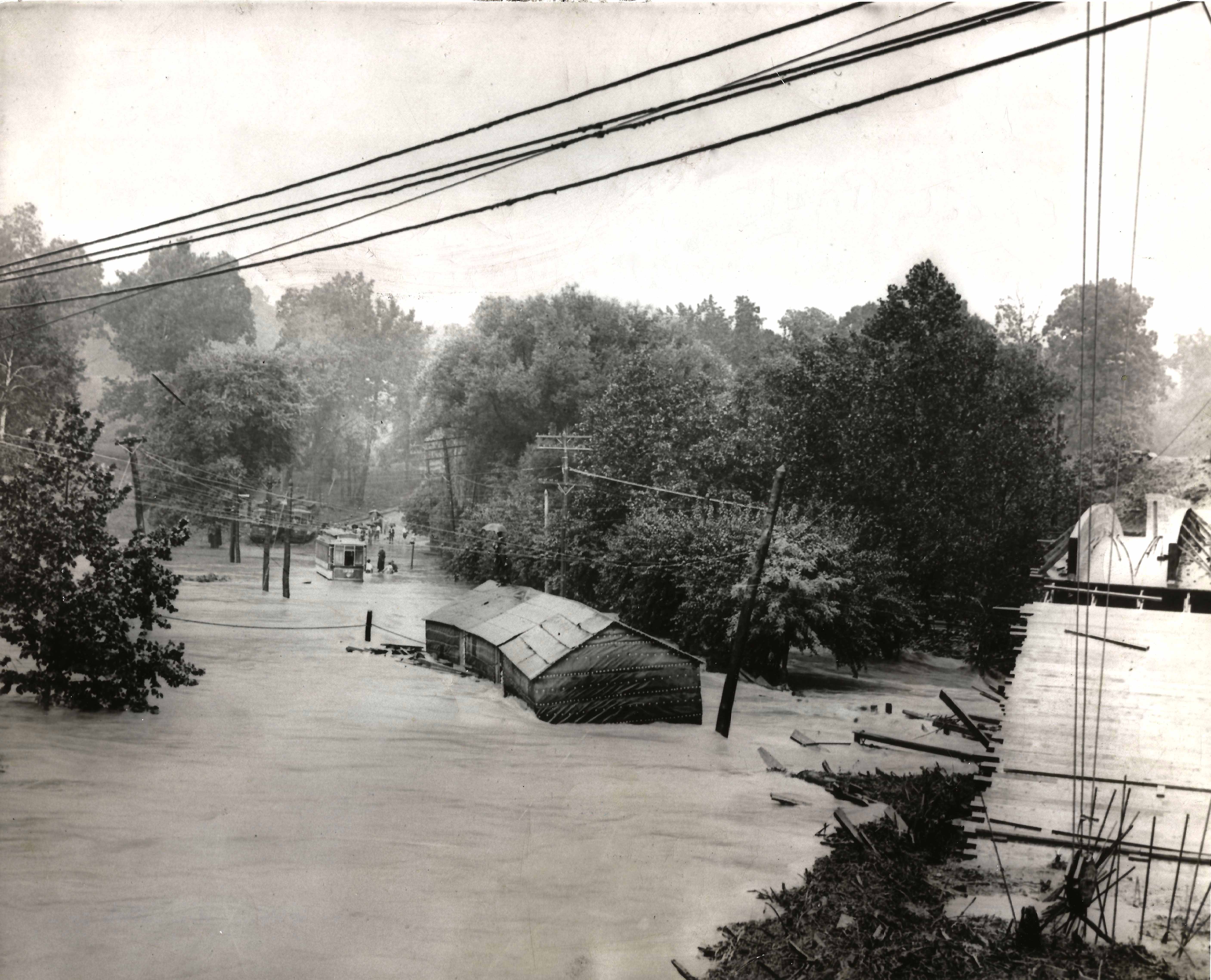
This is how a rain induced flood looked many years ago, Harford rd. bridge to the right.

Belair road bridge would be flooded 4′ above roadway.

Brehms Lane bridge – would also be 4′ under. (Note: Bridge no longer looks like this and there are no longer any horse rides in the park)
