• About
  • History Writings

Water and Me

Water and Me

Tag Archives: Lake Montebello

The Unknowns

20 Thursday Dec 2018

Posted by Ronald Parks in Archives, HISTORY, water history

≈ 5 Comments

Tags

Baltimore, Dams, engineering, FILTRATION, glass plate negatives, Gunpowder Falls, Hampden Reservoir, HISTORY, Lake Ashburton, Lake Clifton, Lake Montebello, Loch Raven, Public Works, water history

As I continue my final countdown to retirement, which started 7 years ago, I have been placing all of my historical research of Baltimore’s Water Supply History onto the City’s intranet and an external hard drive, so that the person that takes my place, Andy, will be able to access the records easier. While moving the electronic files around, I have been coming across photographs marked as ‘Unknowns’, of which some still are, but others, that over the years, I have been able to figure out.

Reflecting back to my early years of doing research, it comes to mind that there has been quite a few people who have helped me along the way…

One such person was Martha, from the Historical Society of Baltimore County. After I cleaned out a room to make way for the new engineers, unbeknownst to me, one of those engineers gave some of our Glass Plate Negatives to Martha. These were over sized negatives that she used a photographic enlarger to make prints out of. At this time I had begun my research, haphazardly I must add! She brought back the negatives with accompanying photographs. Here is one:

From this print I was able to determine that one of my unknowns was a different view of this site – the building of the Montebello Lake Gate House between 1875-1880. Here is the GPN that I found:

For the next couple of years Martha and I would butt heads on how I was doing my documenting/research and that is ok, we all have our opinions. Mostly we butted heads on her grandfather’s house at Montebello. She wants to save it, I would like to see it torn down. I have another blog on here about that.

Sometimes people help with a simple suggestion. I think it was Chris from Facebook who told me this next photo was of the Cross Keys Gate House on Falls Road. Which it turned out to be. The wood structure, which was a storage shed for alum, no longer exists. Soon after this I was invited to a Historical Preservation meeting on designating this as a historical building.

Bill, also from FB helped me with his suggestion on how to restore/fix some of these old photographs by using a simple tool in Photoshop Elements called the Spot Healing Brush Tool. Below is an example, before:

And after.

As can be seen, these photos did not have any markings on them, but by comparing the men in the photos to others, I was able to determine when and where these were taken. Below, one of my favorites, only because the man reminds me of Seth Bullock, was an unknown.

Matching him to another I found, that this was during the building of the diversion sewer around the then being built Lake Ashburton.

This next unknown didn’t really make much sense to me until I found one that was marked from the internet.

Looking close at the one below (Source, Special Collections MdHS) I was able to figure out that the above one is of the Hampden Reservoir.

These next few I had no clue about when I first found them years ago. After lots of research and inquiries from downtown and the public I was able to note that this is of Lake Clifton and its Gate House.

And this one, just marked as unknown, I needed to look at from a different perspective – imagine the front of the building instead of the rear – it is the high service engine house (noted in another blog).

Sometimes the numbers on a GPN helps me figure out what is going on. This one, well not much going on but I was later able to figure out that one of the Water Engineers took this photograph. It was to be the future location of the 1912-1915 site for the new Loch Raven Dam.

Again, a date and a number identifies this one as being part of the collection for the construction of Lake Ashburton. Another tell-tale sign is the engineer’s office in the background, which other photographs have been found, already labelled.

What appears to be a still, which I wouldn’t doubt and that I previously wrote about there being: The Stills At Avalon. Turns out to be where Montebello made there own liquid alum.

Originally marked as unknown and the fact that at the time it was found, I just couldn’t wrap my head around the fact that there was one dam built on top of another at Loch Raven. But this is what is going on here. Sometimes I would mark the photos as unknown if there was no date on them.

A favorite that went along with the above is this one. I knew what the drawing is of, just didn’t know the circumstances of the room. Turns out to be the photographers work shed on site.

This next one, after reading the Annual Reports, turns out to be of City employees searching for 2 boys that supposedly drowned in a quarry. The bodies were not recovered.

This next one is from a collection, another of which I asked the FB public to help me with, but no one knew, is of an ice floe. From the date I am thinking along the Gunpowder Falls? I was hoping someone would recognize the building.

This one, from 1909, I never figured out. I sure would like to find it and see what is at the top of the stairs! 1909 suggests Lake Ashburton. But where??

A few other people who have helped me along the way – Ed Papenfuse, retired State Archivist. Kurt Kocher, DPW Public Information Spokesperson. Rudy Chow, Director of Public Works who gave me permission to continue my research. Tim Bradin, my old boss who let me buy an expensive scanner with City money. All the City employees who kept an eye out for historical stuff just laying around or in the dumpster (received an 1875 drawing that was found in the recycle bin down town). I also thank the Baltimore City Archives, the Baltimore Historical Society, who have always shown an interest in my work, the Historical Society of Baltimore County, the new and old acquaintances I made on FaceBook  and many others. And thanks to Kathy who will listen to my excitement of a new historical find, smiling and wondering what the hell am I talking about, but still encourages me to continue on.

Wow, all those thank yous makes it sound like I am leaving or going somewhere! I am! I am retiring and moving to the Eastern Shore in the next couple weeks – but I will be back!

Tiffany Reservoir

11 Tuesday Sep 2018

Posted by Ronald Parks in Baltimore, engineering, water history

≈ 3 Comments

Tags

Baltimore, bridges, Dams, engineering, Gunpowder Falls, HISTORY, Jones Falls, Lake Montebello, Lake Roland, maps, POLITICS, Public Works, Research, water history

Quite an interesting find: A map from 1867. What makes this map so interesting is that in all my research I never came across any references for having the Gunpowder Falls connected to a reservoir called Tiffany. Everything I read said it would flow by gravity to a new reservoir, Lake Montebello.

First off, let my give a little history on how this water supply came about. Starting in 1836: Samuel Smith, Mayor, appoints a committee to hire the services of a Delaware Engineer named John Randall, to study and recommend a plan for the Baltimore Water Supply. In 1837 John Randall proposed that the City of Baltimore gets its water from the Great Gunpowder Falls. Suggested building two dams, one dam on the Gunpowder near Tysons Mill and the second dam on the Western Run near York Road. Water from these dams was to flow by gravity into the valley of Jones Falls to a receiving reservoir at about Elevation 300. Lake Roland is at 300’

In 1850 consulting engineers are hired to look into Randall’s proposal and then in 1852 a water commission is formed.

1854 Mr. John Smith Hollins, Mayor. Mr. Alfred Duval, Civil Engineer of Baltimore and a private citizen, presented a report to the Council recommending the development of a water supply from the Gunpowder Falls. Duval recommended the building of a dam at Raven’s Rock, the closest point on the Gunpowder Falls to the City, and a tunnel to convey the water by gravity from the dam to a receiving reservoir near Montebello. Mr. Sickles recommended to the Council the adoption of a modified version of the Duval proposal. Mr. Sickles had made extensive surveys and reported to the Mayor and City Council a plan for an ‘air-lined tunnel’ to convey the water of the Gunpowder to the City. An ordinance authorizing such a development was passed by the Council in October but was never signed by the Mayor.

1857 Mr. Thomas Swann, Mayor. Mr. James S. Suter, Water Engineer (April 14, 1857). Original plan for the Jones Falls development was modified by an ordinance adopted in July.  Ordinance instructed Water Commissioners to procure an increased supply of water from Jones Falls “agreeably to a plan heretofore reported to the Council by James Slade, Civil Engineer”. The Water Board is reorganized on April 14 and the first Water Engineer appointed was James Suter.

1860 Swann Lake, (Lake Roland) is completed on the Jones falls.

1861 both the Hampden and Mt Royal Reservoirs are completed.

1866 Mayor John Lee Chapman realizes the approaching inadequacy of Jones Falls as a continuing source of future water supply.

1867 A map of Tiffany Reservoir is drawn up.

As can be seen in this portion of the map below, the location is on the western side of Hillen Road. On a 2018 map it would be the area of Hillen Rd. and 35th St. Where Mergenthaler school is and the area where the houses are on 35th. 

Here is an early photograph of the area where Lake Montebello would be. I am assuming that this is looking east from Hillen Rd to the site of the lake.

And here is an 1880s map showing how the lake and Loch Raven Conduit was (and is) laid out. 

Returning to the Tiffany Reservoir map, a couple things of interest: On the Tiffany map you can see it says Tiffany Conduit connected to Tiffany T (tunnel) then to Herring Run Conduit. Looking close you can see that there are two colorings of this conduit; the first and third sections being blue. The middle section (Tiffany T) is black. All the black sections in this conduit are underground. All the blue ones are open channels. I believe this is where the term ‘Air-lined Tunnel’ came from? That there was not enough head pressure to completely fill the underground portions. Following the tunnel north. The Herring Run Conduit becomes the Sater’s Ridge Tunnel.

And that turns into the Mine Bank Conduit, to the dam at Loch Raven. Another symbol on this map I like is that all the roads pass over the river and streams as regular bridges. On the one below you can see where the road passes over the Gunpowder, below the dam and around the corner, it is colored in, which shows that back in 1867 there was a covered bridge at Cub Hill and Cromwell Bridge roads. 

A couple more items of interest on this map – The location of Glenn Ellen Castle.

Swann Lake (Lake Roland). The title of the Tiffany Map is somewhat wrong. It states “In connection with the Swann Lake Aqueduct.” I believe it should say “In relation to”. On this map I do not see it connected.

The Hampden (Noted as Hampton on map) and Mt. Royal Reservoirs.

And this map portion that shows the Johns Hopkins property before it became Lake Clifton, and a race track in the lower right corner. In a few years from this map’s date, a Baltimore County water filtration plant will be built near the track; using ozone filtering technology. (I forget off hand what the date was – maybe 1907?)

And finally, on the map title is HMF v Stamp as the Chief Engineer. I could not find anything about this person until 1873 where he is listed as the contractor to build the Temporary Water Supply, from the Gunpowder to Roland Run, which fed Lake Roland. It consisted of a couple pumps near Meredith Bridge, running some pipes to dump into Roland Run.

The Tiffany Run Reservoir was never built. Lake Montebello was. Many droughts, flooding of the Jones Falls and finally and over polluted Jones Falls required the new, permanent Gunpowder Works to be built – and is still in service today.

Note: This map is too brittle and too large for my scanner.

Montebello and the Panama-Pacific Exposition 1915

22 Friday Dec 2017

Posted by Ronald Parks in Baltimore, Dams, HISTORY, water history

≈ 2 Comments

Tags

Baltimore, Dams, engineering, FILTRATION, glass plate negatives, Gunpowder Falls, HISTORY, Lake Montebello, Loch Raven, maps, Montebello, Public Works, Research, water history

Finishing up documenting a Water Board Minutes of Meetings Journal, I came across a couple of interesting tidbits concerning the connection between Baltimore and San Francisco. In 2015 we both celebrated a 100 year anniversary. Them celebrating the 1915 World’s Fair and us the building and opening of the Montebello Filtration Plant. The connection being this – February 11, 1915 It was resolved by the Water Board to send the Filtration and Dam models to the Panama-Pacific Exposition. According to the model itself, it was completed in December, 1914.

Here is a lantern slide copy of the model. If you visited Montebello during our 100th anniversary and took a tour, you would have saw the actual model.

The lighting in the hallway is terrible with all the reflections. It was too dark with the lights out and too reflective with a flash.

Here is the nameplate data on the model.

Along with this one. I did a search for information on this company but could not find much. And something else I could not find is – where is the model of Loch Raven?

Howell’s did a pretty good job replicating the filtration plant.

The plant as it looked in the 1920s.

I don’t know about anybody else, but I’d like to put little people in here…and maybe Godzilla!!

Showing what the waste lake looked like.

And the detail of the outfall structure.

The waste lake dam and outfall structure being built. Notice the date – October 1914. This means that the model was built conceptually, like an artist’s rendition of something before it is there.

Of course, one research item always leads to more.

In 1884 models of the substructures were built and placed in each gatehouse, Loch Raven and Lake Montebello, to give visitors a better understanding as to how each works. (What happened to them?)
February 6, 1893 the Water Board resolved to send a display to the Columbian Exposition. This was 21 years before the Howell Microcosms were built. so what did they send?
November 18, 1935 letter from M.P. McNulty, he has just completed creating a model of the Loch Raven dams and inquires as to the dates the real dams were built. Small replies that the lower dam was built between 1875 and 1881 by Fenton and Jones, Contractor. The upper dam was constructed by King-Ganey starting in 1912 and finished in 1914 and then raised between 1920 to 1922 by Whiting-Turner. Attached to the letter was a newspaper clipping which shows a picture of the model. (This clipping is at the City Archives)
December 31, 1952 letter from William Eichbaum Scale Models informing Hopkins that they will build a new, Montebello Plant model in the existing case for $1,000.00. This was not done.
And for what appears to be a wonderful book – San Francisco’s Jewel City: The Panama-Pacific International Exposition of 1915 by Laura Ackley


Water History Drawings

03 Friday Nov 2017

Posted by Ronald Parks in Baltimore, engineering, water history

≈ Leave a comment

Tags

Baltimore, bricks, engineering, Gunpowder Falls, HISTORY, Lake Montebello, Montebello, Public Works, Tunneling, water history

I love it when engineers, from the real world outside of Montebello, send me historic drawings. Not only did he send me some really nice ones, he gave me a link to thousands of others. I’m glad someone else in the Water Department, besides me, is saving our history. Here is one that threw me off at first glance.

I know where the drain tunnel is off of Lake Montebello, but looking close at this drawing and at a recent photo I had taken of the drain where it enters Herring Run, something just didn’t look right.

Here is the photo from my inspection down there. Looks about right, but, the drawing says it is of the West Portal? West? This is east of the lake as shown in the 1894 topography below.

To the right of this kidney bean shaped lake is a small arrow pointing to the drain. Then looking close to the left, near Hillen Road is another portal. This is west. Also, the top elevation of 146′ matches the drawing. The east portal top elevation is about 120′. I wish I had photos of when this structure existed. It is all built over now. Under Hillen Road is a large storm drain – 9-12′ that goes into the gate house (Structure with unknown quarter moon shaped object next to it).

Here is another drawing, unknown location because all the shafts were filled in. (Unknown, even though it gives the station as 22+50. Without the overall view, I’m not sure where the engineer started his stations? 2,250 feet from where?

It shows how they built these tunnels, by hand, through solid rock. Bottom legend shows cost and materials. Thanks Engineering!

Thanks

18 Wednesday Oct 2017

Posted by Ronald Parks in water history, Writing

≈ 2 Comments

Tags

Baltimore, engineering, FILTRATION, Gunpowder Falls, HISTORY, Lake Montebello, Loch Raven, Montebello, photography, Public Works, Research, water history, writing

Just want to thank the person(s) that bought 6 copies of my book yesterday. I receive a sales report, but there are no names attached. Thank You!

Building Montebello Filters and Loch Raven Dam

12 Thursday Oct 2017

Posted by Ronald Parks in Archives, HISTORY, water history

≈ Leave a comment

Tags

Baltimore, Dams, engineering, FILTRATION, Gunpowder Falls, HISTORY, Lake Montebello, Loch Raven, Montebello, POLITICS, Public Works, Research, water, water history

I am now in the process of documenting Water Board minutes from 1912-1919, Baltimore City. Over the course of blogging water history, some readers had asked information concerning relatives that may have worked on the New Dam at Loch Raven and/or constructing the Filtration Plant at Montebello. These ledgers have list of employees and their addresses and in some cases, their titles and pay rates. If you think this may be you, send me their names and I will try to look up that info. Keep in mind this is for the above dates. Once I am finished documenting, these books are going into the archives…

Swimming Bathing Drowning

06 Thursday Jul 2017

Posted by Ronald Parks in Baltimore, HISTORY, water history

≈ 3 Comments

Tags

Baltimore, engineering, FILTRATION, Health, HISTORY, Jones Falls, Lake Montebello, Loch Raven, Montebello, POLITICS, Public Works, Swimming, water history

For your summer reading pleasure:

1916: A 16,000 gallon swimming pool was being built next to Lake Roland. July 19, 1917 letter from Water Engineer Walter Lee to the Baltimore County Commissioners asking that they police the area around Lake Roland as it has been reported that 10-15 persons bathe there every day. They reply that the city should get their own men to do it. June 9, 1923 letter requesting permission for the L’Hirondelle Club to be allowed to swim in Lake Roland. March 1924 newspaper clipping on drowning of boy, thirteen, in Lake Roland. The city investigation tried to place blame on the Pennsylvania Rail Road, who they say had some timbers floating about, which the boy fell off of as he used them as a raft. The PRR said it was a contractors fault, who used the timbers for some work they were doing. They also note that the boys were trespassing at the time of the incident. October 10, 1917 letter from Walter Lee to Mayor Preston notifying him of the intent of two ladies from Hampden, asking that a swimming pool be constructed on the property of the Hampden reservoir. They were also soliciting for his honor to pass a city ordinance in which they were to propose. Lee asks that if this happens, would the mayor turn the property over to Park Board? June 20, 1922 letter from Megraw to Christhilf Construction and other contractors, asking that they put in a modest bid (For charities sake) for the construction of a swimming pool at West Park (New name of Hampden Reservoir area) March 22, 1923 memo concerning the creation of a swimming pool between the upper and lower dams complete with toilet, shower facilities and a snack shack. June 20, 1924 letter from Armstrong to Siems concerning the swimming in the waters between the dams. He says it is prohibited. June 20, 1926 letter from the Baltimore Federation of Labor to Bernard Siems concerning the city using non-union workers to build the Druid Park Swimming Pool. On the bottom of this memo is a union logo: Specify UNION LABOR, have the job done Right!

Druid Park Swimming Pool

July 11, 1927 letter from Wolman to Wieghardt, “…when the pool was inspected by us a couple years ago we were informed that the Hampden Reservoir contained filtered water…the Hampden reservoir obtains all its water from the Jones Falls. In other words, the pool has been obtaining a completely untreated water from a relatively dangerous source, which has been abandoned for all municipal purposes for over 10 years…” July 14, 1927 letter refers to the Hampden Reservoir area as Roosevelt Park instead of West Park. June 24, 1930 memo from Rost to the Police Commissioner asking that the police stop the boys from climbing over the fence and swimming in the Montebello Plant II filtered water reservoir. 1932 Pools listed are: Druid Hill Colored Pool, Druid Hill White Pool, Gwynns Falls Park Pool, Carroll Park Wading Pool, Riverside Park Pool, Patterson Park Pool, and Clifton Park Pool.

Clifton Park Pool

June 10, 1933 police report on a ten year old who went swimming with three other youths and he drowned. The others left him and told no one. July 18, 1935 request from the National Guard for a shooting range at Loch Raven. Small does not want this. August 15, 1935 Brigadier General Washington Bowie writes Small back stating, “I note what you state in regard to the interference with the recreational purposes. If you had been with me last Sunday…when I saw three negroes in bathing suits swimming back and forth near where I wish to locate the range, or on a previous occasion when I found a half-dozen white boys swimming…I think you would find a rifle range more desirable than such recreational use…the portion outlined on your print is constantly used by both negroes and whites for swimming. The rifle range would at least make this unpopular.”  Bowie then goes over Small’s head to Crozier. Crozier agrees with Small. A few months later, the Mayor agrees with Small and Crozier. June 14, 1938 list of names of swimmers at Loch Raven. Officer Goetz is to arrest these people and take them to Towson jail if they are caught again swimming in the reservoir. June 14, 1945 memo from A. Bailey to L. Small concerning kids swimming in the waste lake, “The boys in the Northwood neighborhood…are using it as a swimming pool…groups up to about thirty…during the daylight and night hours, sometimes as late as 12pm. They have been warned a number of times by various employees of this division only to be cursed for their troubles…radio police have been summoned but made no attempt to stop this practice…I talked with two patrolmen while eight to ten boys were in the lake and asked that they talk to the boys…they promised they would but walked to the opposite side of the lake and blew their whistles instead. Yesterday, June 13, there were even a greater number of swimmers than any time previous, so I contacted these boys personally and told them that it was my orders to have them arrested…they paid little attention to what I said…placed twelve ‘No Trespassing’ signs up. By 9pm all signs but one were removed and destroyed. At 10pm, a great commotion was heard, a group of three boys were in swimming and one had gotten into trouble and was so far gone when they rescued him, that it was necessary to apply artificial respiration…police called and all three were taken to Sydenham Hospital. The police, at least the patrolmen, do not seem to want to cooperate with us and make no attempt to put a stop to the practice of swimming. (We) could drain the lake and keep it drained in the summer months…parents may then be willing to stop their kids, but judging from what I have seen of these people, I do not believe they have enough control over their children to prevent them from doing anything that they wish to do. Child delinquency for this section is bad, if not worse than the average for Baltimore City. August 23, 1945 memo from Bailey to Strohmeyer about unwanted visitors to the plant. Young men swimming in the waste lake, one almost drowned. Two, three year olds, alone, swimming in waste lake. One threw a fit and refused to leave. The police were called. Two teenagers running through Plant II and when told to leave, went and got their father who dared anyone to stop them from coming into the plant. An undated memorandum: “Yesterday afternoon … three young men found swimming in the Balancing Reservoir at Loch Raven in their birthday clothes.”

Gwynn’s Falls Pool – the overflow goes right into the stream, adding more pollution.

The largest of the pools back then.

Tunnel Inspection Part 2

30 Friday Jun 2017

Posted by Ronald Parks in Baltimore, engineering, water history

≈ 2 Comments

Tags

Baltimore, bricks, engineering, FILTRATION, Gunpowder Falls, HISTORY, Lake Montebello, Loch Raven, Montebello, nature, Public Works, water, water history

Over a year ago I was asked to be part of an inspection team, to walk/boat through the 12′ tunnel that connects the Loch Raven Reservoir to the Montebello Filters. This tunnel was built between 1875 and 1881. In the early years it was inspected quite often. In the 1960s it was decided, after a parallel tunnel was built in the late 1930s, to reverse the flow in this old tunnel to supply drinking water to Towson via the Cromwell Pumping Station. The old tunnel was last inspected in 1984. For that info you can see my post linked here:  https://rep5355.com/2016/04/06/tunnel-inspection/

In preparation for the inspection, I did all the necessary training – Red Cross/CPR, Confined Space, etc. Then we were told that it was too unsafe to send anyone in the tunnel. Totally bummed!

So now they have finally gotten around to inspecting the tunnel with a remote operated vehicle. It has been a long week starting last Friday. First order of business was to clear the site for the contractor to bring in his equipment.

Area cleared and the phragmites sprayed.

Next, construction mats were placed across the phrag roots – which is very soft. (And the equipment very heavy) These boards did the trick.

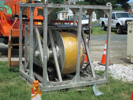
The equipment was unloaded. This is the inspection vehicle. It is about 14′ long and weighs 1500 pounds.

This is the tether. The sub is connected to this. It is 7 miles long, but only needs to go 5-1/2 miles.

The sub will enter at the top right. This is looking down the shaft towards the tunnel.

Here she goes.

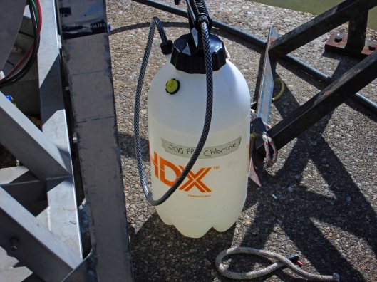
Because this is a pipe that is in use, with drinking water, everything that enters the water was sprayed with a chlorine solution.

The control center. All this information on all these screens will be made into a report for the City to decide if the tunnel is still usable. The interesting one is bottom center. If you watch that and there is a change in the circle, say a rise in the bottom, that means the sub is going over a rock fall. You then look at the camera display and you can actually see it.

In my previous tunnel inspection post is a photo where the balancing shaft enters the tunnel at Cromwell. It is mostly smooth. Unlike this entry point – it looks like someone busted thru the top of the tunnel with a sledge hammer.

The sub was moving at a nice pace – looked like the Enterprise going at warp speed! Not sure what those particulates are just yet. Probably just some stirred up lime deposits.

And when I got bored, I went looking for nature. There are 3 young bucks…

A couple babies.

An Eastern-eyed Click Beetle

Bunches of other bugs.

And our night time visitor looking for food.

Saving History, One Piece at a Time

16 Friday Jun 2017

Posted by Ronald Parks in Baltimore, HISTORY, water history

≈ 3 Comments

Tags

Baltimore, Clifton Gate House, Dams, engineering, FILTRATION, Gunpowder Falls, HISTORY, Lake Montebello, Loch Raven, Montebello, POLITICS, Public Works, water history

Anyone that has been following my blog will remember my writing about a few construction projects that are water related. Such as the new buildings at Loch Raven, the contractor busting a hole in the ten foot conduit that supplies water to Baltimore, another contractor digging up the foundation to an old pumping station, the attempts to save the Clifton Gate House, the Roland Tower, the residence at Montebello, etc.

When I first wrote about the work along Loch Raven, I wrote about the house and buildings they were tearing down. After being notified of this project, I went to investigate and saw a bunch of metal signs. Not necessarily ultra historic, but a part of Baltimore’s Water Supply History nonetheless. I was able to retrieve from the contractor, 2 of the 8 that were there. The other six were taken by a company the reuses old building materials.

Here is one of the eight signs. This all happened a few months ago. The other day I received an email. One of those courtesy type ones from the big bosses downtown, trying to keep me in the history loop. Well, I was dumbfounded when I read the email. It just said FYI and had the attached photo along with two other attachments.

I couldn’t believe what I was seeing! This photo is of the marble plaque that was in the original 1881 gate house to the first Loch Raven Dam!!! i always wondered what happened to this thing.

The third attachment is a quote, only partially shown to protect the parties involved. Two marble plaques? The quote went on to say that the other one was dated 1887!! Holy crap! Only one water works related to Loch Raven was built at that time and that was the Clifton Gate House!! My eyes were playing tricks on me!! This couldn’t be!

But wait! How did this company get these things and were they really trying to sell them back to the City? City property??!! I don’t think I ever cussed in an email to one of the bosses downtown but I just couldn’t contain myself “What the hell! This is City property. How can they charge us for something that is ours?!” I suggested he gets the Environmental Police involved to check this out. If not, tell them I will give them $500 and we won’t press charges. He said he turned it over to the EP. And he did. Today I received a copy of the investigative report stating that these items were picked up by accident and would be returned to the City. And they were this afternoon!!

More on this later so stay tuned! (I want to go into a lengthy bit of comment on what we should learn from this…)

Clifton Gate House – Update

19 Wednesday Apr 2017

Posted by Ronald Parks in Baltimore, Gate House, water history

≈ Leave a comment

Tags

art, Baltimore, engineering, FILTRATION, Lake Clifton, Lake Montebello, Montebello, photography, POLITICS, Public Works, water history

Back in July 2016 I wrote about the renewed interest in doing something with the Lake Clifton Gate House. A farmers market, a cafe, a historical showcase for the water department, etc. The other day I received an email to attend a meeting on another proposal, submitted by Civic Works and their vision for the Valve House (Note: Valve House and Gate House are interchangeable when talking about this structure – Pump House is not – it never had pumps in it). Attached to the proposal was this photograph:

I thought to myself, how the heck did I miss this driving back and forth to City Lights?? Well, this didn’t happen. It is a piece of art. “This is an animation of a specific artist’s winning proposal to mount this public art installation. BOPA is hoping that the installation will be able to move forward under the watchful eye of Civic Works.”

Here is an excerpt from John, at Civic Works, on their proposal for the Gate House:

When the Valve House is renovated and attractively landscaped, it will attract people who pause for pastry, coffee, ultra-local freshly harvested foods and flowers, art and stories of Baltimore. Stories from our past, presented here, will be outshined by news of the structured opportunities, offered “next door” for careers in the expanding green business sectors.

As the renovations to the Valve House are fully realized, the adjacent Lake Clifton campus will become the operational base for Baltimore Center for Green Careers, Civic Works Food and Farm programs and other pathways to prosperity. In the coming decades, these two work in harmony – the information packed social hub and the sustainable-jobs work preparation center.

I personally think this is a great idea! And I really hope it happens.

Here is a 1927 aerial of Lake Clifton and its relation to Lake Montebello. Clifton being the one at the bottom. Water flowed from the dam at the Gunpowder Falls, via a 7 mile tunnel to Montebello, then by conduit to Clifton, at which point it was dispersed to the city.

From the 1970s showing the interior of the Gate House with the water chambers covered over with wood.

The reverse of the above photo, from the Sunpaper files showing that back in 1970 there was an interest in restoring the Gate House.

Another 1970s Sunpaper photo showing the stained glass windows nearly intact. Most have since been broken out. (Note:Photos from my personal collection)

← Older posts

Blogroll

  • Flouride Action Network
  • lulu
  • My Book
  • WordPress.com
  • WordPress.org

Recent Posts

  • In Search of The Skipjack Ada Mae
  • Trap Pond Kayak
  • Pusey Trail and Cemeteries
  • Chandler Tract (White Trail) 4 3 21
  • Oyster Fritters, Antiques, a Hike (and a bad sign)

Blog at WordPress.com.

  • Follow Following
    • Water and Me
    • Join 228 other followers
    • Already have a WordPress.com account? Log in now.
    • Water and Me
    • Customize
    • Follow Following
    • Sign up
    • Log in
    • Report this content
    • View site in Reader
    • Manage subscriptions
    • Collapse this bar
 

Loading Comments...