• About
  • History Writings

Water and Me

Water and Me

Category Archives: HISTORY

Jones Falls Flooding and Proposed Improvements

14 Thursday Apr 2016

Posted by Ronald Parks in Baltimore, HISTORY, Sewage History

≈ Leave a comment

Tags

Baltimore, engineering, Health, HISTORY, Jones Falls, maps, Public Works, sewage, Sewage History, water history

First map – July 1868. Showing Plat and Sections of Streets Submerged by Flood Exhibiting Proposed Changes Projected to Relieve the City Against Future Overflow by Latrobe, Trimble and Tegmeyer, Commissioners.

The area between the green lines is the flooded zone. The blue is the proposed changes. The grey being the actual Jones Falls. The smaller diagrams show the various streets and how high the water was when they flooded. It appears that the Falls rose about 20 feet in spots. The lower left diagram shows the proposed changes to streets.

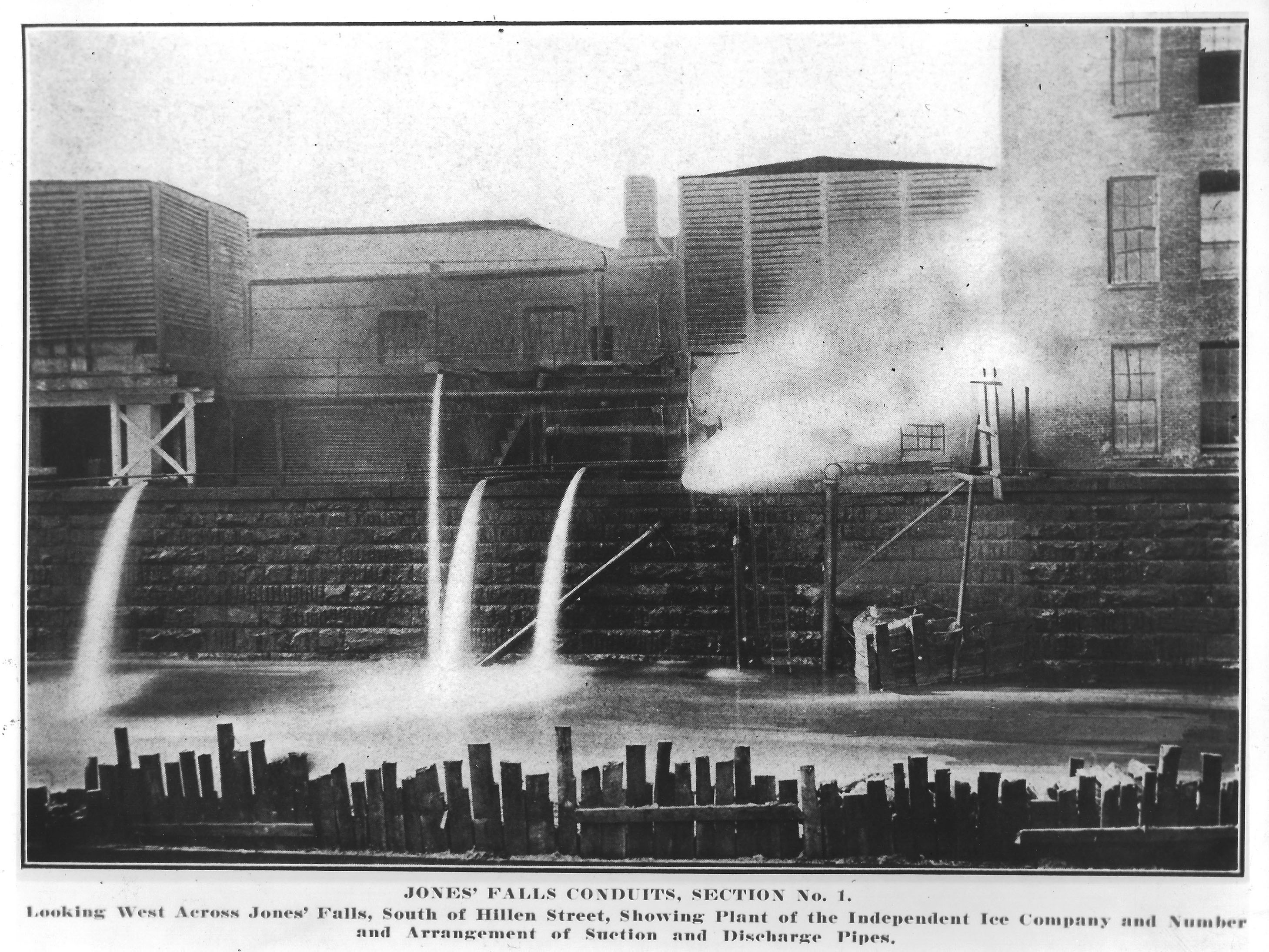
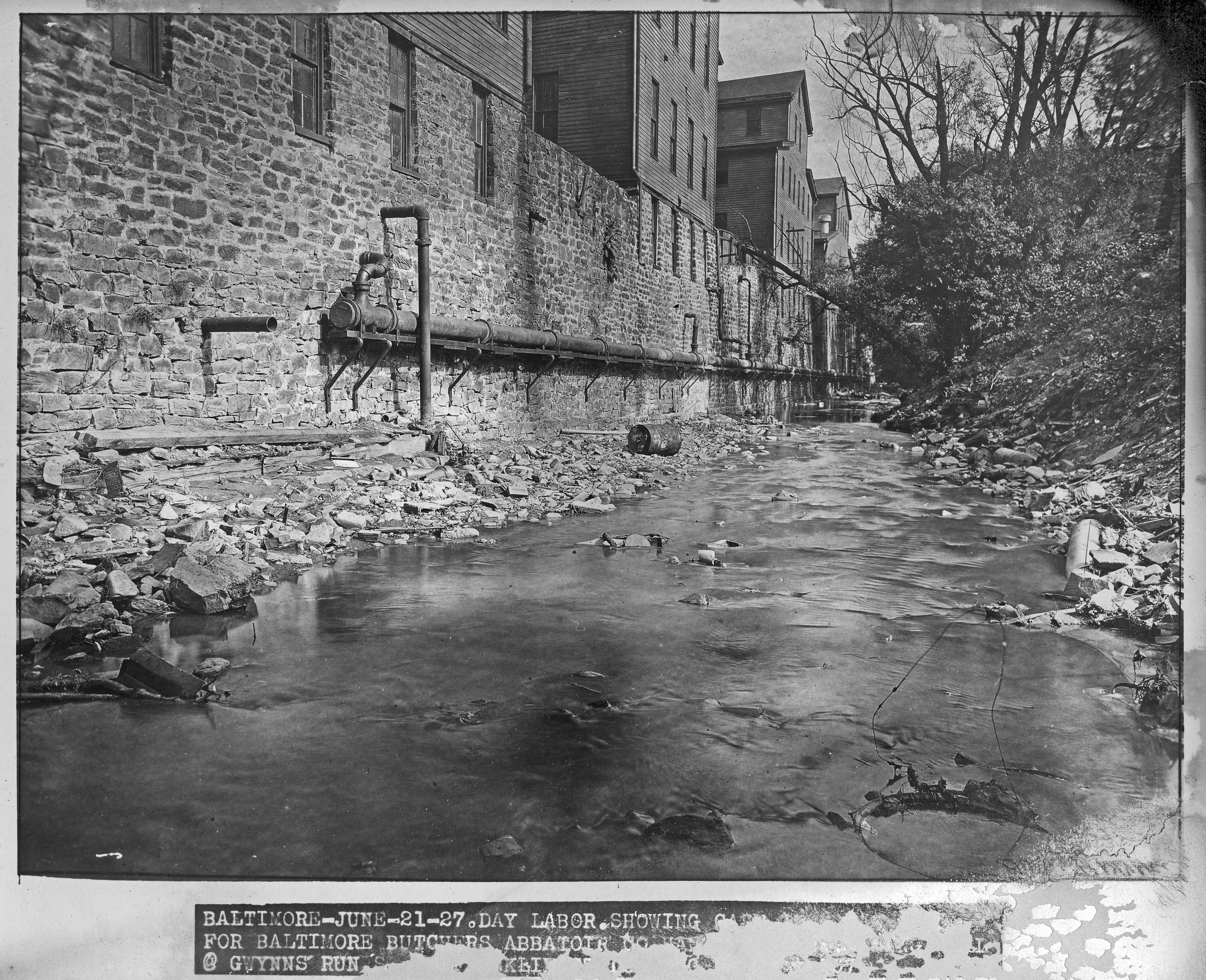
A few things I find interesting is; the drawing of the skating pond as being the former City Reservoir (Possibly the second Mt. Royal?), The number of small dams, and all the businesses along the Falls that contributed to the pollution – gas, coal and oil factories, tannery, brewery, sugar refinery, lime kilns, oyster packing and taverns. Not to mention all the residences along the Falls. The City Dock and Block St. drawbridge I will write about later.

Plat and Sections of Streets Submerged

Second map – April 8, 1869. Revised Design for the Improvement of the Channel of Jones Falls and Drainage to Adjacent Portions of the City by H. Tyson. Note in upper left – The original design for this improvement will be found in the report made at the request of the Committee of Property holders of the Flooded District on the 31st of July, 1868.

This map shows the flooded area in a darker tan with numbers indicating the depth of water in feet, i.e. 15’ at Saratoga and Holliday. The proposed Falls is in pink with proposed sewers in red. The Falls is green.

Interesting with this map are the cut-away views showing sewers of Brooklyn, NY and of London. Also the cut-away views of the new retaining walls with sewers running along the Falls. I especially like the Baltimore St Bridge drawing with boat. (They dredged the Falls a lot for the passage of ships to merchants. More on that later) Note the wooden pavements above the sewers in the lower diagrams to the left. Houses and businesses were also built over the sewers. If you are from Baltimore, note that Alice Ann St. was 2 words. Now it is Aliceanna. Canton Ave. is now Fleet St. The note/drawing on bottom shows bridges, then and proposed over the Falls.

Revised Design for the Improvement of the Channel

Brock Mill Pond NC

04 Monday Apr 2016

Posted by Ronald Parks in HISTORY, Photography, Travel

≈ Leave a comment

Tags

engineering, Hiking, kayaking, mills, North Carolina, photography, water history

Took a road trip to Indian Beach, North Carolina the other day. On the way we stopped at an old mill, c1700s. Nice.

P1060471

Too bad it was closed for the day – would like to see the inside workings.

The dam

The pond – Kayak adventure waiting to happen!

Kerbs

23 Wednesday Mar 2016

Posted by Ronald Parks in HISTORY, Sewage History

≈ Leave a comment

Tags

Baltimore, bricks, engineering, HISTORY, Public Works, sewage, Sewage History, water

From the 1899 Commissioner’s Report on stormwater, sewers and streets – Referring to the present condition of the paved streets of Baltimore, I cannot say that they are in good or bad condition, as this is a relative term, and depends a great deal upon what residents are accustomed to, what advanced civilization requires and the willingness of the tax-payers to keep pace with the same. We have succeeded in the last year in repairing most of the places which were specifically complained of, and have done much to make the best of bad pavements. The kerb-stones are far from being in repair, but the citizens become so accustomed to seeing them lay over in the gutter, or partially so, that they have long since ceased to make an outcry concerning the same, especially as it involves an outlay on the part of the property-holder to repair his footway; but we have succeeded in resetting more kerb this year than any previous year, over ten miles.

1900 curb

Storm Water Study

11 Friday Mar 2016

Posted by Ronald Parks in Baltimore, HISTORY, Sewage History

≈ Leave a comment

Tags

Baltimore, engineering, FILTRATION, HISTORY, Lake Montebello, Montebello, sewage, Sewage History, water history

When the sewer system was to be built, a separate and independent storm water collection system was also constructed. This seemed to work fine in the early parts of the 1900s, but as the City grew, problems arose and this is what happened next:

1948 Annual Report – It has been recognized that the technology of storm drainage design could be improved if a better experimental background were established to guide the designer. To accomplish this purpose, the City together with the Baltimore County Metropolitan District and the State Roads Commission of Maryland have agreed to jointly sponsor a Storm Water Research Program to be conducted at the Johns Hopkins University.

1959 Annual Report – A Parshall flume was installed in the vicinity of the outlet of a 48” drain at the east side of Hillen Road south of Argonne Drive in order to measure the amount of run-off from a shopping center (Northwood) type of drainage area. Both rainfall and run-off data for this area are collected by automatic recording devices.

1965 Annual Report –  The Storm Water Research Program is in its 17th year (and still no results mentioned)

I found the structure where this site was located on our property. I sent off an email to Johns Hopkins University to see what became of the report. You would think that a study conducted for 17 years would have a report. The Environmental Engineering section and others have no clue what happened to that study?? 077

This is the structure where the recording equipment was stored. The door is padlocked but I was able to stick my camera under it to see what is in there – nothing but an old recording device.P1060414

Here is the guy that was guarding itP1060418

This is the 48″ drain from the Northwood shopping center.

I was looking for historical information on this study but at the same time, the plant was receiving complaints that the Montebello Lake had a green tint to it. Besides the processes inside the plant, this is the only other source of water that empties into the lake. The lab is now analysing the water to see what caused the discoloration.

Rendition – Sewage Pumping Station

07 Monday Mar 2016

Posted by Ronald Parks in Baltimore, HISTORY, Sewage History

≈ Leave a comment

Tags

art, Baltimore, engineering, Health, HISTORY, Jones Falls, Museum, Sewage History

Below is an artist rendition of what the Eastern Avenue Pumping Station was to look like in 1907. I found this water color drawing at the DPW Museum, tucked behind a bunch of wet, moldy boxes (some museum pieces were damaged by water and fire years ago). I am hoping to take this art work and have it restored soon. I like that the artist also included the Baltimore Shot Tower in the background, to the right. With the coal bins above the steam boilers, that ran the pumps, the coal was unloaded from rail cars and ships, then conveyed to the top of the building. It fell into hoppers and the hoppers fed the boilers. Engineering marvel. The building is being considered as a Historic Landmark.

The building is still pumping sewage every day. Where the boilers once were, had been converted into the DPW Museum, which has been closed for a few years.

IMG_1797

Where to Start?

03 Thursday Mar 2016

Posted by Ronald Parks in HISTORY, Sewage History

≈ Leave a comment

Tags

Baltimore, engineering, HISTORY, Jones Falls, Museum, Public Works, sewage, writing

My original intention, to post on here, was to do so in chronological order, the building of Baltimore’s Sewage and Storm-Water systems. But, as can be seen in the tables below, a lot was going on all at one time. So the photographs and comments will be scattered. My new book will not be, hopefully!

The information that I present here comes from a wide variety of reports that I have read and sorted out. A couple years ago I was asked to document the archives from the Public Works Museum in Baltimore. I also was asked to move these archives to another location, which I have done. The artifacts, files, photographs, etc were stored in a fairly haphazard way. Scanning, photographing, reading, inventory, documenting….well, this is what I do.

So much information and so little time!

From the 1908 Annual Report: It is reported that the City has saved upwards of $1 million on construction cost due to breaking the work up into smaller portions so the competition for bidding would be greater. List of contracts and contractors.

chart

chart2

Testing Plant

25 Thursday Feb 2016

Posted by Ronald Parks in HISTORY, Sewage History

≈ 2 Comments

Tags

Baltimore, engineering, FILTRATION, glass plate negatives, HISTORY, Jones Falls, sewage, water history

1906 – Before building a complete, City-wide sewerage system, a Testing Station was built to figure out the best means of treatment.

At Hampden and Walbrook, surveys were made and every house located, and in each place a plan for a comprehensive sewerage system was made. As a result of these studies Walbrook was selected as offering the most advantages.

Establishment of experimental testing station at Walbrook: In accordance with the Chief Engineer’s recommendation, the Commission on June 14th, 1906 authorized the erection of an experimental Testing Station. On October 2nd sufficient land was secured, without charge, from the Walbrook Land Corporation for the site of the Testing Station, for a period of seven years. On October 10th the contract for the erection of this testing station was awarded to the lowest responsible bidder, Malcolm W. Hill Company of Baltimore, Md., at their bid of six thousand, nine hundred and thirty dollars and forty-seven cents ($6,930.47). The contract for the Laboratory Building in connection with the Testing Station was awarded to the lowest responsible bidder, Wm. Kirkpatrick, of Baltimore, Md., on October 18th, at his bid of three thousand, seven hundred and fifty dollars ($3,750.00). The contract for the permanent sanitary sewers which will lead to the Testing Station was awarded to the lowest responsible bidder, M. A. Talbott & Company, of Baltimore, Md., on October 29th, at their bid of thirty-three thousand, two hundred and thirty dollars and ninety-eight cents ($33,230.98).

1907 – “Sir: In obedience to the requirements of Section I, Chapter 349, of the Acts of the General Assembly of Maryland for 1904, this Commission has the honor to make a report of its official transactions for the year 1907.” The first sanitary sewers to be constructed were those in Walbrook for the drainage of houses embraced within a prescribed area, and which were constructed as auxiliary to the experimental testing station, as part of the permanent system. Work on outfall sewer and interceptors was begun. There was criticism as to the size chosen for the sewers, but the Commission stuck to the plans of the advisory engineers: Rudolph Hering, Samuel Gray and Frederick Stearns.

These photos show constructing the Testing Station and Lab. Also the sprinkling filters.

81_6_56 81_6_159 img041

1908 sewage map walbrook

Here is the only reference I could find concerning the exact location of the Testing Plant.It comes from the Johns Hopkins Sheridan Library. I cut it down in size for viewing here. The location is never mentioned in any of the Annual Reports other than “Walbrook”. The testing plant is represented by the two circles at the bottom of the dark lines, just above Patterson Ave.

From Sewage Commissioner’s Report: The sewage testing part of the laboratory has been closed for a number of months, but the testing of all materials for construction work is being carried on, which has proved of great value in getting desired results. The plant is continuing to receive and purify the sewage carried to it from the system of sewers throughout Walbrook. On account of the disposal plant being operated by gravity, the cost of maintenance is reduced to a minimum.

1904 Fire

24 Wednesday Feb 2016

Posted by Ronald Parks in Baltimore, HISTORY, Sewage History, water history

≈ Leave a comment

Tags

Baltimore, engineering, HISTORY, Jones Falls, sewage, water, water history

Many of the history books that I have read concerning Baltimore, all point to the Great Fire as the reason for new water and sewer systems. But as I read thru the records of the Commissioners and Engineer’s Annual Reports, it shows that the need for new sewage works was on the minds of every Baltimorean as early as 1815. With the increase of the water supply, from the Gunpowder River in 1881, there was an enormous amount of waste – cesspools and privies overflowed so badly that the Baltimore Harbor became a disgrace.

Here is a view of the 1904 fire in Baltimore: Courtesy of the DPW Museum and the Peale Museum

img092

Pollution of the Jones Falls

18 Thursday Feb 2016

Posted by Ronald Parks in Baltimore, HISTORY, Sewage History

≈ Leave a comment

Tags

Baltimore, engineering, Health, HISTORY, Jones Falls, photography, sewage, water history

As previously mentioned in another post, the Jones Falls suffered much flooding along with a tremendous amount of pollution.

The below photograph shows a storm drain dumping into the Falls. This one was fed not by just the rain onto the street, but by the houses and over-flowing cesspools.

img107


This photograph shows an ice company dumping its wasted water into the Jones Falls, then pumping the water back out, to make ice.

001


And this is a meat packing plant, slaughter house, that dumped all its waste into Gwynns Falls, which also dumped into Baltimore’s Harbor. This photograph came from an album that was first in a fire (at the warehouse it was stored) and then suffered water damage. The caption underneath reads: …for Baltimore Butcher’s [Abattoir] (slaughterhouse) Co ? @ Gwynns’ Run…

img011

Drift-Catcher

11 Thursday Feb 2016

Posted by Ronald Parks in Baltimore, HISTORY, Sewage History, water history

≈ Leave a comment

Tags

Baltimore, engineering, HISTORY, Jones Falls, sewage, water, water history

When I first saw the structure below, in the color photographs, I thought it was some sort of old pedestrian bridge. After some research, and a look through the DPW Archives, I found the following information:

On June 9 and 10, 1911, Messrs. Hering, Gray and Stearns again visited Baltimore for the purpose of inspecting Jones’ Falls above North Avenue Bridge, also to examine the plans for a drift-catcher, and on July 27 reported to the Commission approving the plans, etc., of the Chief Engineer. The drift-catcher, or interceptor, will be constructed at a point south of the Cedar Avenue Bridge, most available from an engineering and practical standpoint, rights having been obtained, without cost, from the Northern Central Railway, which owns the property on the west side of the Falls, and from Mrs. Fannie A. Timanus, on the east side

Appendix A: Report of the Consultant Engineers. Concerning a drift catcher and Jones Falls conduits. We have considered Mr. Hendrick’s suggestion of the possible obstruction of these conduits by trees, bridges, small buildings or other things which might be washed away by a phenomenal flood, such as is provided for in this case, and while it seems probable that with conduits of such magnitude nearly all large objects would pass through without obstructing them, some large objects, if not intercepted elsewhere, might lodge on the dividing walls at the head of the triple conduit and cause an obstruction. We, therefore, approve the adoption of some plan which will provide at a suitable place above the head of the conduits means for intercepting large floating objects.

The arch and pier type of structure, which we approve, is shown in part upon the preliminary plan furnished by Mr. Hendrick, entitled “Studies for Drift-Catcher,” and in part upon a plan, dated July 12, 1911, giving alternate designs of the drift-catcher. The general design consists of narrow piers about 20 feet high, spaced 8 feet apart from center to center, held at the bottom by being concreted into pits excavated in the rock, and at the top by a horizontal concrete arch extending from one side of the valley to the other and abutting against the ledge.

Completed in 1912.

067107029 (2)

← Older posts
Newer posts →

Blogroll

  • Flouride Action Network
  • lulu
  • My Book
  • WordPress.com
  • WordPress.org

Recent Posts

  • Bermuda 2023
  • ICELAND April 2023
  • George Chalmers of Fochabers
  • In Search of The Skipjack Ada Mae
  • Trap Pond Kayak

Blog at WordPress.com.

  • Subscribe Subscribed
    • Water and Me
    • Join 231 other subscribers
    • Already have a WordPress.com account? Log in now.
    • Water and Me
    • Subscribe Subscribed
    • Sign up
    • Log in
    • Report this content
    • View site in Reader
    • Manage subscriptions
    • Collapse this bar
 

Loading Comments...