• About
  • History Writings

Water and Me

Water and Me

Tag Archives: water history

Loch Raven Property Part 2

14 Wednesday Jun 2017

Posted by Ronald Parks in Baltimore, Dams, HISTORY, water history

≈ 8 Comments

Tags

Baltimore, Dams, FILTRATION, glass plate negatives, Gunpowder Falls, HISTORY, Loch Raven, nature, Public Works, water, water history

Back in December I posted information about a house that was being torn down to make way for a new Loch Raven Reservoir Maintenance building(s). Some questions came up as to who owned the house originally and how long had it been there. Just recently my blog had been read and I have been in communication with two brothers that lived there. Their grandfather was the superintendent of the property from the fifties to the eighties.

I found this photo and the accompanying info sheet on the property.

Back in 1932 a handyman lived there named William Butcher. The brother’s names are Joe and Jim Greenwood. Their grandfather’s name was William Farrell. They are going to try and find some photographs of when they lived there.

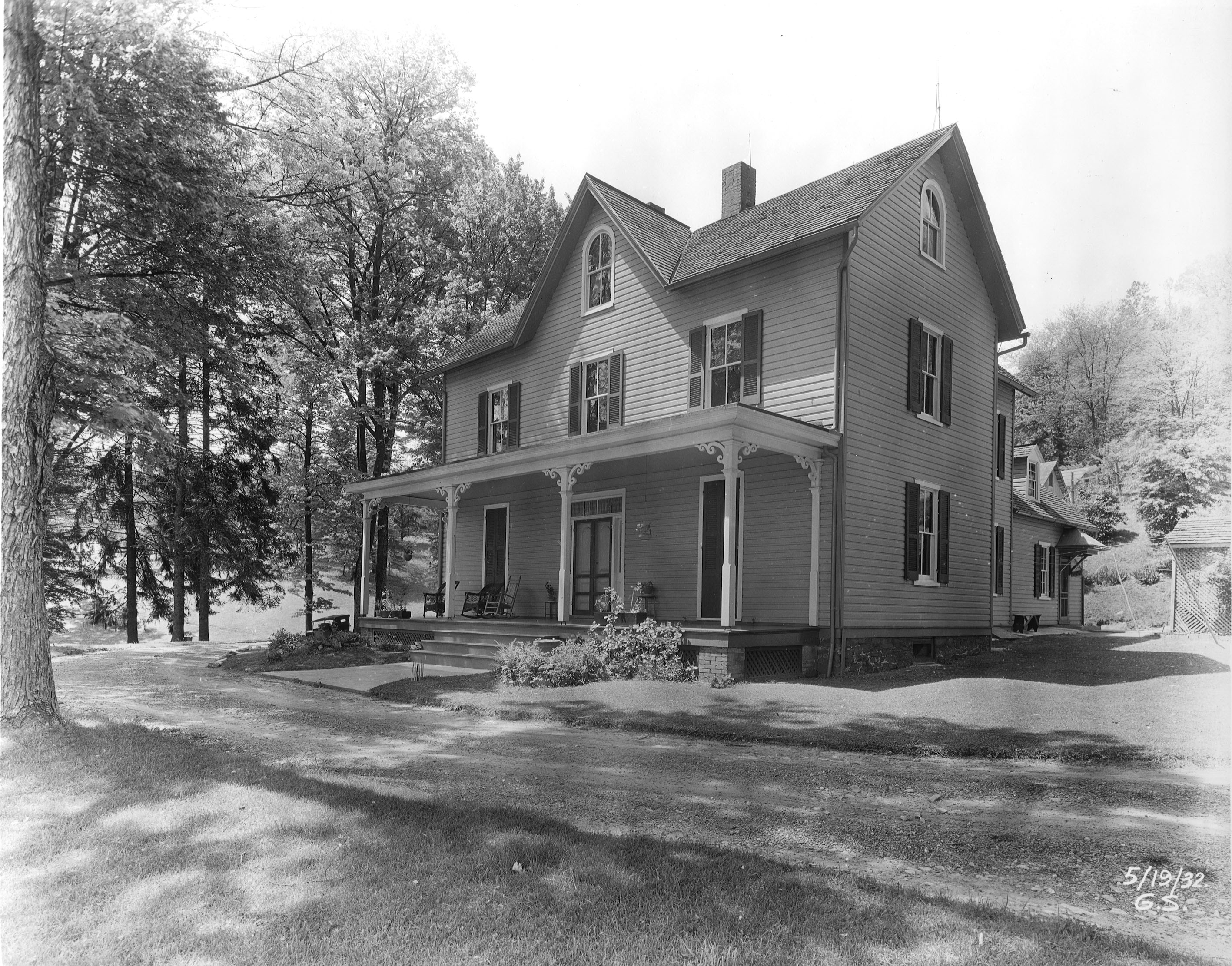
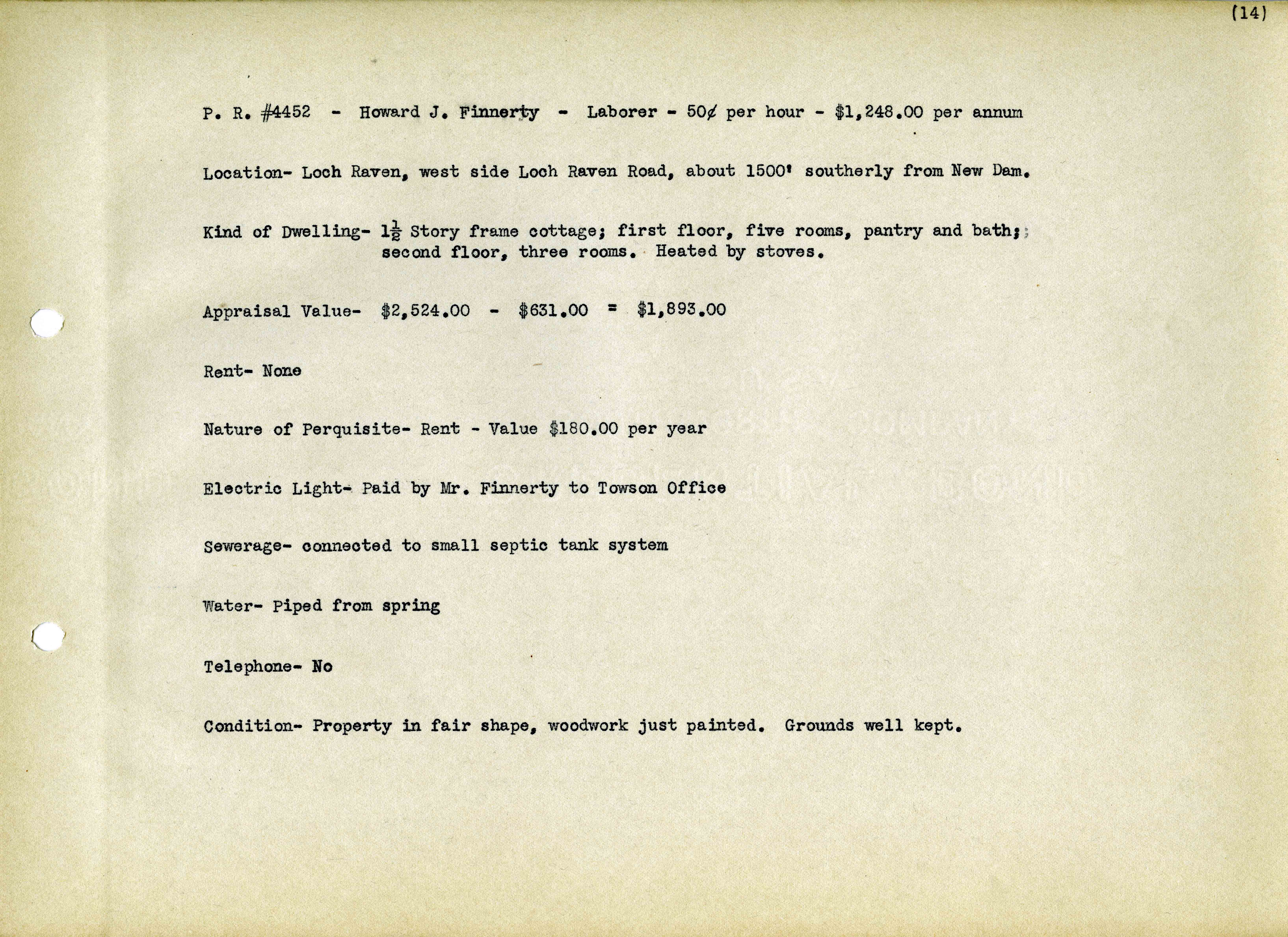
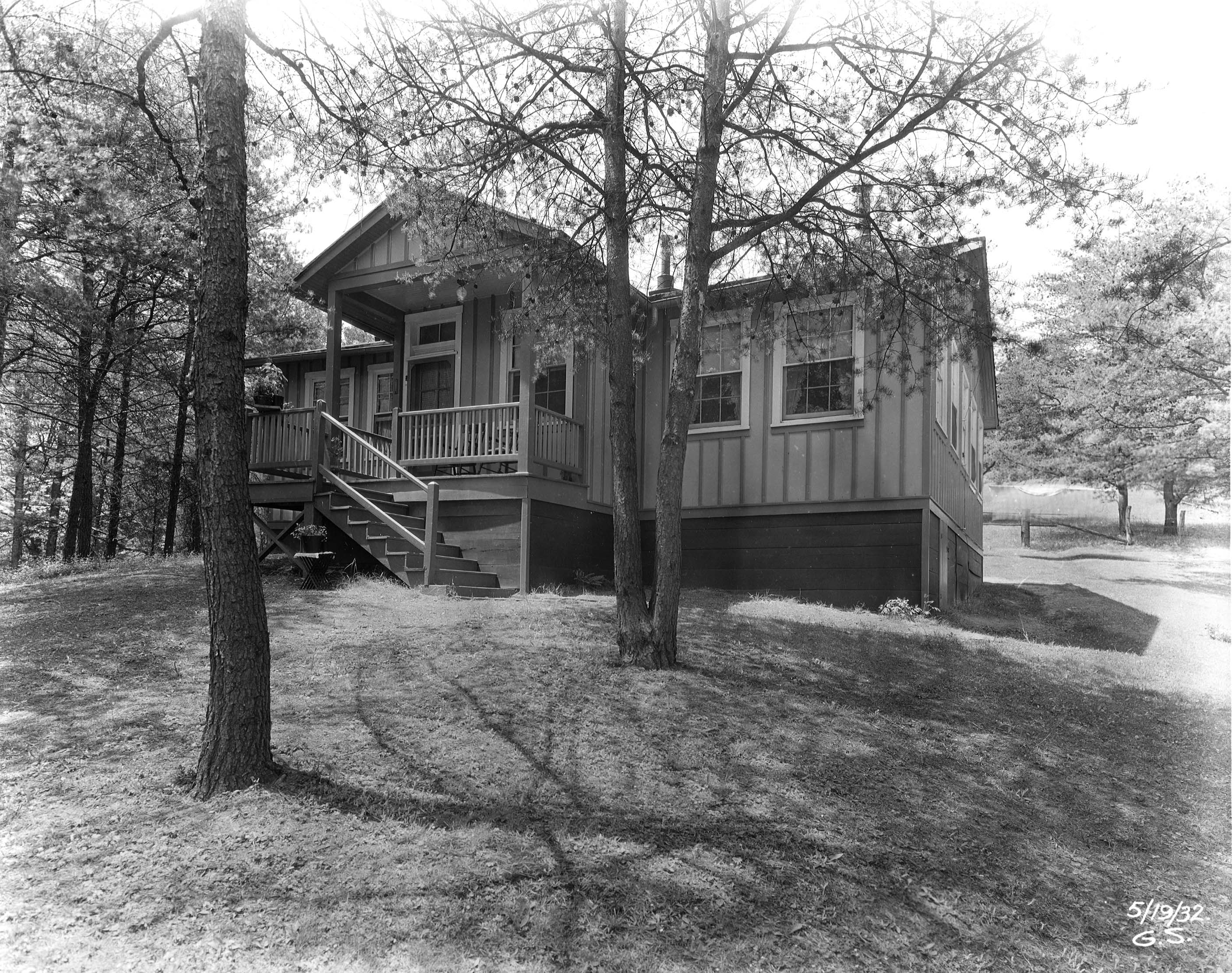
In my records is this house, occupied by Howard Finnerty.

As can be seen, this house was 1500 feet south of the dam, which puts it just north of the Butcher property.

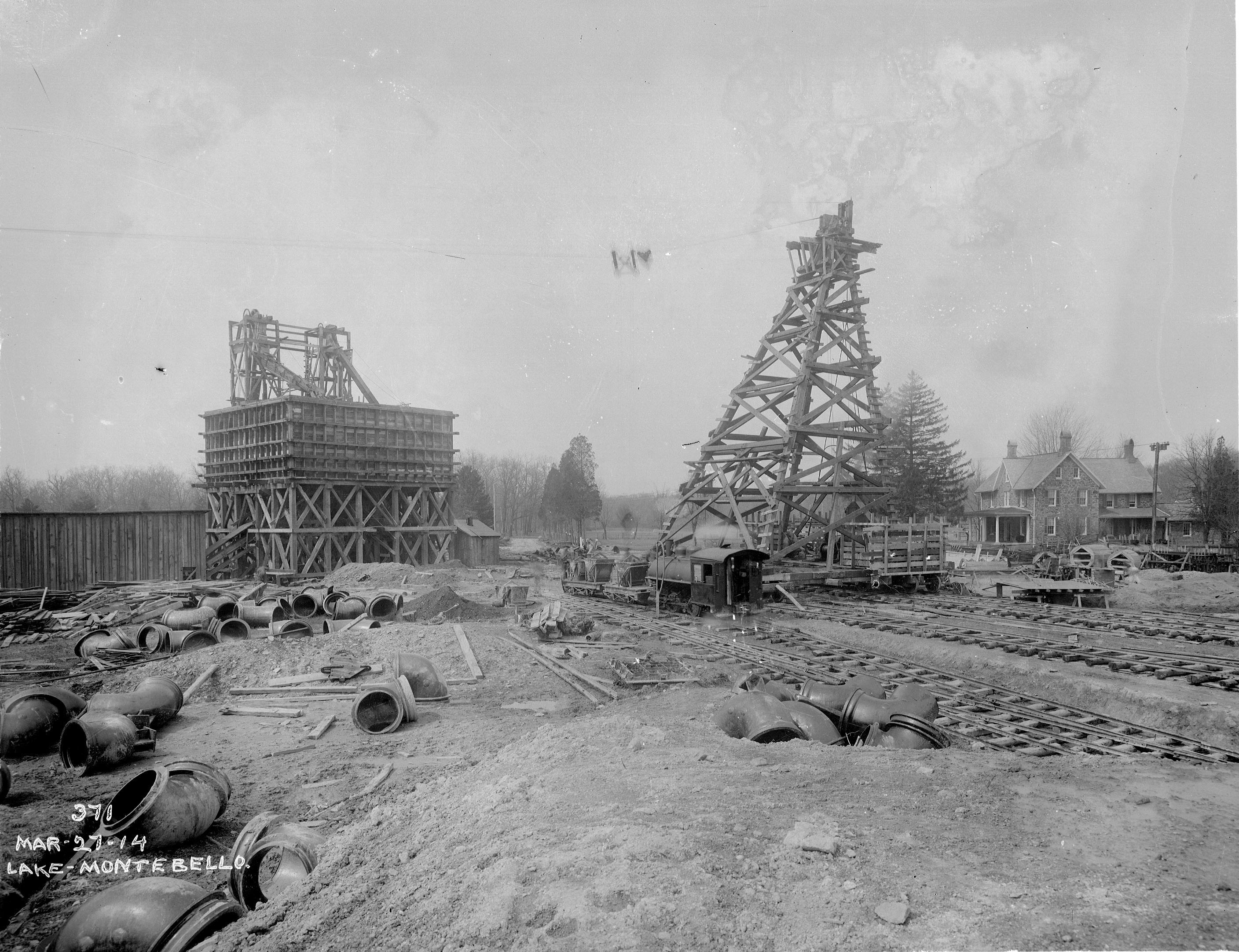
Enlarging this photo from about 1914, you can see both houses to the left.

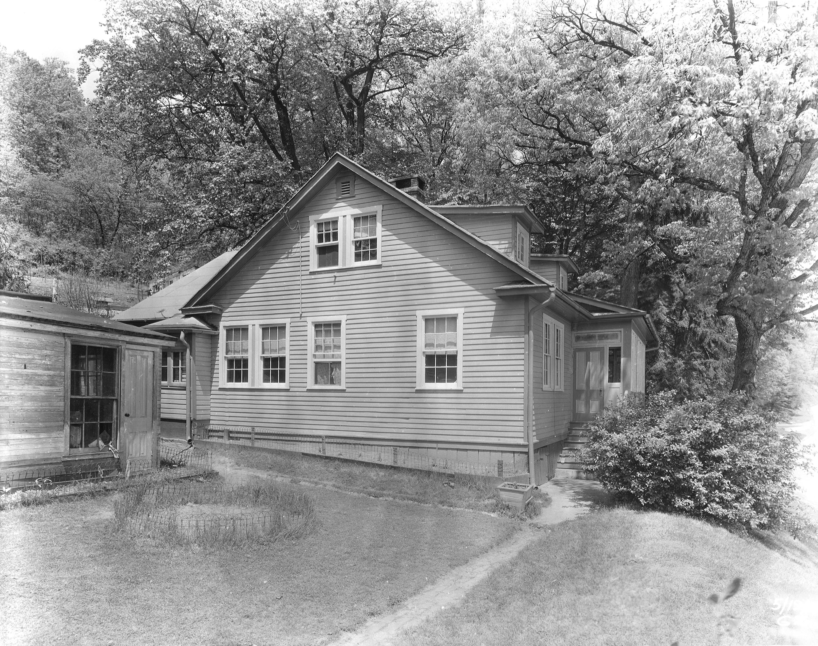
Another interesting house adjacent to the property was occupied by John Chenowith.

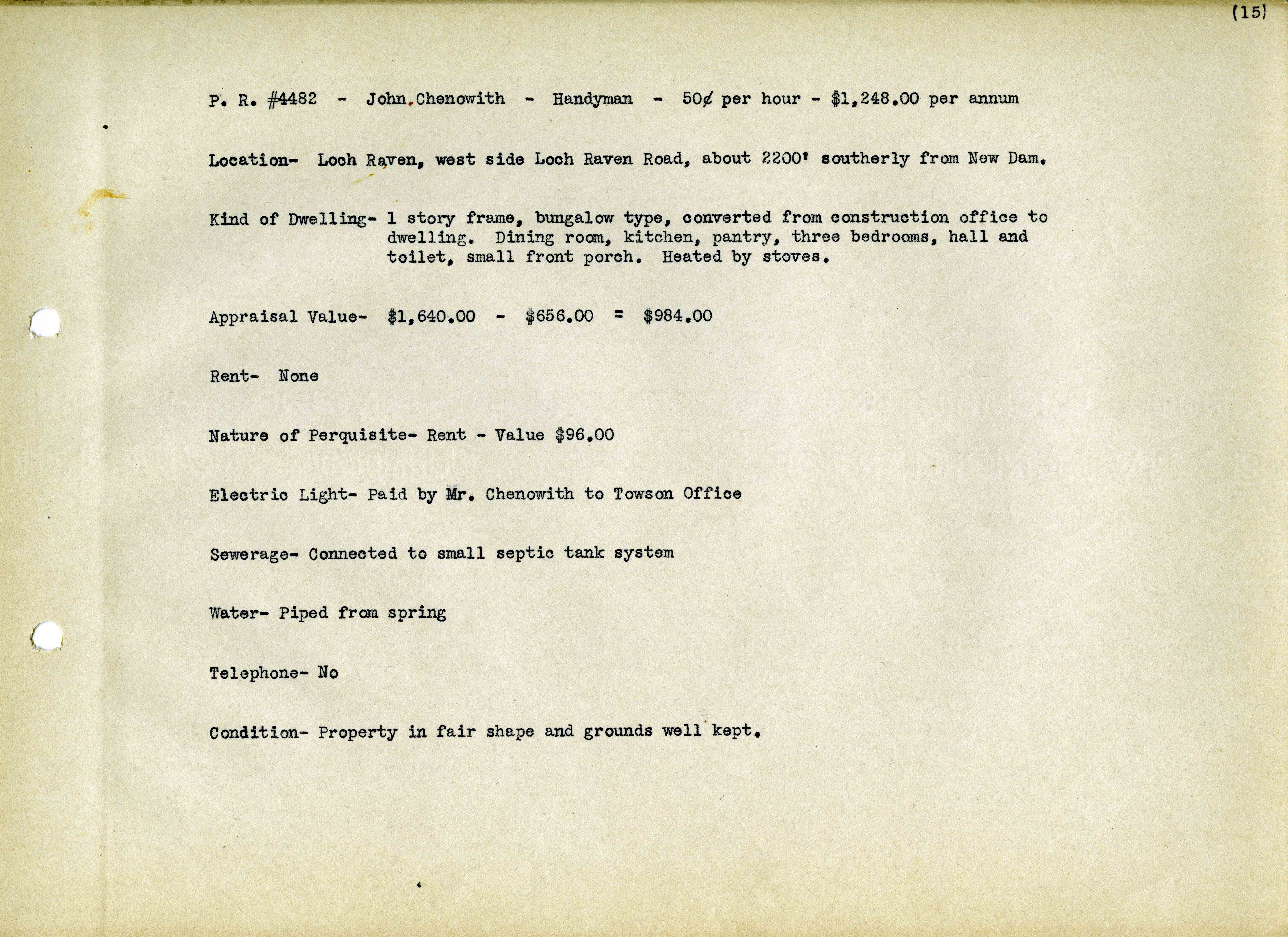
According to this record, the house was 2200 feet from the dam which kind of puts it just south of Shanghai Run, on the hill. I did find a photo that LOOKS like this house from 1914 but I am not sure.

Here is some of what the brothers said about growing up on Loch Raven:

• Jim Greenwood said: June 12, 2017 at 4:15 pm
According to family history, the home was built in stages sometime before the Civil War. The kitchen section was built first, then the center section, then finally the large section up front, including the porch. It was later bought by the city.
The house was always occupied by the Superintendent up until 1980 when my grandfather retired. Legend has it that General Harry Gilmor spent time in the house during his adventures in the area.
Many, many stories. I remember evacuating the house during Agnes, and ice skating below the lower dam in the winter, and hearing about Chuck Thompson at the fishing center (a celebrity!) In the 60s we’d get trapped in the house as the road became gridlocked with folks cruising in their cars and flat lands below the dam became a big parking lot/beach party every weekend. In the mid-seventies they planted trees below the lower damn and closed the road on the weekends and the hippies were replaced by bicyclists.
Despite the beautiful photos, the area between the dams was usually a mud pit with a stream of water trickling down the middle.
My grandfather kept a close eye on the place, and we always enjoyed him shouting from the front porch at people getting into things they shouldn’t get into.

• Joe Greenwood said: June 13, 2017
I think Chuck Thompson came to one of the crab feasts. Several barrels of steamed crabs from Hale’s for the then crazy sum of $100 each.
Winter was always fun for us with the salt trucks going in and out and never understood why our grandfather hated snow. Greatest sled hill in the world up behind the pumps and the old foundation up on the hill. We somewhat had the run of the place since all the workers knew us and we would despoil Uncle Bill’s penny jar and walk to Sanders’ at the juncture of Cromwell Valley. If nothing else, we could check on the dead cat along the way and occasionally didn’t catch fish off the little dam while the hippies jumped off it. It was always fascinating to talk to Clarence, who tended to come on duty in the evening to patrol and was missing a finger and was always happy to show us his pistol.
We did get in a little trouble like accidentally throwing kerosene on the workers’ wood stove.

So now the question comes up! Should this house have been torn down before doing a thorough investigation? Gilmor??

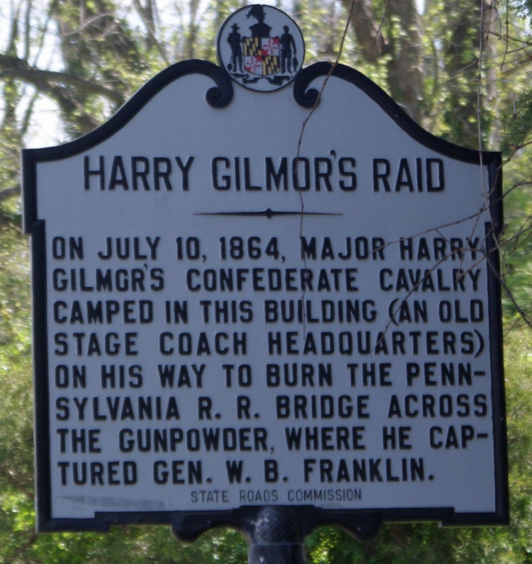
This is a historic marker up off of Mountain Road, not too far from Loch Raven. Which brings up another question – since a lot of people are so hell bent on erasing history, by removing Confederate statues – should all the Highway Markers also be removed?

Thanks to Joe and Jim Greenwood for your stories. This is what makes my job so interesting.


When they were giving out brains, you thought they said trains…

30 Tuesday May 2017

Posted by Ronald Parks in Baltimore, engineering, water history

≈ Leave a comment

Tags

Baltimore, engineering, FILTRATION, HISTORY, Montebello, POLITICS, Public Works, Research, water history

Contractor on site called me over once again because they hit something unknown.

Turned out to be a set of train tracks from original construction 1913-1915.

As can be seen here, there were a lot of tracks laid for construction. These veer off to the right to hook up with the ones below.

In this photo, lower right is about where the tracks are that the contractor dug up. I told them they would have to suspend their work until I talk with the historical people – these may be the tracks that President Woodrow Wilson’s train was on during his visit when the plant opened in 1915. Not. Montebello Lake is in the background.

Patapsco SP, Avalon

22 Monday May 2017

Posted by Ronald Parks in Baltimore, Hiking, HISTORY, water history

≈ 2 Comments

Tags

Baltimore, bridges, engineering, Hiking, HISTORY, maps, mills, nature, photography, state park, water history

Due to the possibility of rain, we decided to go hiking at Avalon in the Patapsco State Park instead of going kayaking. I have a new phone app called All Trails which is pretty cool. It documents your hike.

Although it says we were moving for 1 hour and 25 minutes, we were actually there for 3 hours. It does not record every time you stop to enjoy the sights, sounds and smells. That is indicated by the thicker line, where we deviated from the trail. Lots of honeysuckle out. The only thing I did not like about this hike was the amount of bikes flying through there. Some had bells, most didn’t.

Entering the park, one of the first things you see is the Thomas Viaduct.

This photo is from the 1930s I believe (DPW Archives). It shows an older train and a newer one from that time.

This photo I took 5 years ago, the last time I visited the park. Soon after this, my Konica Minolta camera would die on me. It was a good camera.

Of course I had to check out the old water works, or what is left of them. Here is some info on that:

On September 30, 1921, the City of Baltimore took over operation of the filters at Avalon. By the purchasing of the Baltimore County Water and Electric Company, the City received a dam and filtration plant on the Patapsco River at Avalon. After this, the filters at Herring Run, near Philadelphia Road, were abandoned and the sand taken to Avalon. Ten years later, the City stops using it.
Of interest is the following:
1923 Correspondence between Edward Rost (Mechanical Engineer), [V].B. Siems (Water Engineer), Edmund Budnitz (Federal Prohibition Director) and A. Bernard Siems (Water Engineer). Concerns sampling water at the Rockburn Branch (Patapsco River), Avalon Pumping Station for pollution caused by illicit liquor still smashed up by Government agents. How the Feds destroyed it and dumped it into the stream, causing the contamination. Excellent description of how the still was built and operated: They built a small dam with a hand pump for water, pumped through a rubber hose and iron pipe to twenty-seven wooden boxes made of pine, made water tight with muslin. They also had a vertical high pressure steam boiler. Scattered around were half gallon mason jars, corn meal and liquid mash. It was suggested by Siems that the mash be hauled away to a local farmer’s manure pit. A follow up letter to the feds by Siems asking that they clean up the corn mash they dumped everywhere, which is still contaminating the stream.

One of the many trails. According to All Trails, there are over 20 miles of trails here.

Tunnels to the other trails.

Another one.

Besides the tunnels to the other side of the train tracks, there were many storm drains. This one had a Tulip Poplar Tree flower. Fell right in place for all to enjoy.

One of our off-trail forages to the river, we came across this guy. There was also an osprey and maybe an adolescent eagle.

Up stream a ways is the swinging bridge. I could swear that when I was young, this bridge was made of rope and wood and it really swung. Now it just kind of bounces.

Five years ago. It was pretty clear under the swinging bridge.

Plein art at the entrance to Cascade Falls.

Well worn trails.

The lower portion of the falls.

Cascade Falls.

Kathy contemplating the sights and sounds of the falls. Molly contemplating how to get off that log and back to land.

Heading back, following the river instead of the trail. Dumpster?

Had trouble finding this guy. An oil tanker that was washed away during Hurricane Agnes, 1972.

This is 5 years ago. So only recently did they (Park people) allow it to get so overgrown. There is a historic marker on the trail – The Forces of Nature.

Walking along the river, found a lot of Sea Glass – actually I guess it is river glass. Also there was an electrical insulator. Found some really nice glass and porcelain. (Kathy found most of it)

A nice day and a wonderful hike. Five years ago I did this hike by myself. It is nice to have someone with me, to enjoy this.

Ghost in the Conduit

18 Thursday May 2017

Posted by Ronald Parks in Dams, engineering, HISTORY, water history

≈ 8 Comments

Tags

Baltimore, Dams, engineering, FILTRATION, fishing, Gunpowder Falls, HISTORY, Loch Raven, Montebello, Public Works, water history

Awhile back I had posted some photographs of the construction work at Loch Raven. The contractor hit and poked a hole through the ten foot conduit that supplies water to Baltimore from the Loch Raven Reservoir. Fortunately, another one of the conduits was in service, so the damage did not affect our drinking water supply. This conduit was installed in 1915. It is riveted, welded steel. Some portions are encased in concrete and a good portion is lined with cement.

I would like to thank Pure Technologies for giving me permission to use their photographs.

Pure crew heading into the conduit. This is near Mine Bank Run, heading towards the dam. The water would eventually be at chest level.

This was interesting and took a little research to figure it out. The smaller opening on the right connected to the 1880 rock and brick tunnel. In 1937 they built a parallel pipe line from Loch Raven to Baltimore and that is the conduit on the left. There is a valve in the smaller pipe stopping the flow of water towards Baltimore. Down stream further, the raw water pipeline becomes potable water from Baltimore, to Towson, at Cromwell.

Continuing the inspection of the conduit. Pretty good shape for being over 100 years old.

The fish like the water (Baltimore water finished in the top ten again this year in a national taste test)

Not sure what this is. Looking at the drawings I saw where there is a drainage system under the steel conduit. But didn’t see this in the drawings.

Pure finally reached their destination. The damage is a little more than we thought. The cement lining has been knocked off.

It is about a 3’x4′ section of damage.

This is the hole that the excavator punched through. There are also about 5-6 dents in the pipe.

When the inspection crew climbed out, I think they brought something with them…

Random Archives

04 Thursday May 2017

Posted by Ronald Parks in Baltimore, HISTORY, Sewage History

≈ Leave a comment

Tags

Baltimore, baseball, Democrats, Latrobe, mayor, plumbing, POLITICS, Public Works, Research, Sewage History, stadium, water history

Sorting and documenting more archives from the DPW Museum.

January 24, 1884 Letter from the office of J.E. Clark & Co., Wholesale Liquor Dealers, No. 48 S. Howard St. Baltimore to Hon (Honorable) (Mayor) F.E. Latrobe: Dr. (Dear) Sir, We take pleasure in recommending hon (honorable) Jas. McFarland for the position of Inspector of Weights and Measures! From our long acquaintance with him, we can endorse him as a man of strict honor & integrity and should you appoint him, we feel satisfied he will give general satisfaction to the trade. Respectfully Yours J. E. Clark & Co.

May 15, 1923 Letter from Stehley Plumbing to the Mayor and the sewerage engineer Ruark asking for a sanitary sewer in the alley, houses along Hamilton Ave. and ? (Where Remmell Ave. is now)(Not sure if initials in upper right are Mayor Broening’s? Note says to notify plumber when plans are completed).

I looked on a few maps and still cannot find the name of the intersection that 3815 Hamilton Ave. was at back then. Someone once asked me when did Northeast Baltimore get a sewer system? It was about this time.

A photo I posted on Facebook a couple years ago, showing Sewerage Maintenance trucks and workers back in 1928, parked in front of the Baltimore Stadium.

Democrats doing the Hip-Hop back in 1900! I looked up the 21st District to see where the China Hall was located. Found China Alley but no Hall.

Clifton Gate House – Update

19 Wednesday Apr 2017

Posted by Ronald Parks in Baltimore, Gate House, water history

≈ Leave a comment

Tags

art, Baltimore, engineering, FILTRATION, Lake Clifton, Lake Montebello, Montebello, photography, POLITICS, Public Works, water history

Back in July 2016 I wrote about the renewed interest in doing something with the Lake Clifton Gate House. A farmers market, a cafe, a historical showcase for the water department, etc. The other day I received an email to attend a meeting on another proposal, submitted by Civic Works and their vision for the Valve House (Note: Valve House and Gate House are interchangeable when talking about this structure – Pump House is not – it never had pumps in it). Attached to the proposal was this photograph:

I thought to myself, how the heck did I miss this driving back and forth to City Lights?? Well, this didn’t happen. It is a piece of art. “This is an animation of a specific artist’s winning proposal to mount this public art installation. BOPA is hoping that the installation will be able to move forward under the watchful eye of Civic Works.”

Here is an excerpt from John, at Civic Works, on their proposal for the Gate House:

When the Valve House is renovated and attractively landscaped, it will attract people who pause for pastry, coffee, ultra-local freshly harvested foods and flowers, art and stories of Baltimore. Stories from our past, presented here, will be outshined by news of the structured opportunities, offered “next door” for careers in the expanding green business sectors.

As the renovations to the Valve House are fully realized, the adjacent Lake Clifton campus will become the operational base for Baltimore Center for Green Careers, Civic Works Food and Farm programs and other pathways to prosperity. In the coming decades, these two work in harmony – the information packed social hub and the sustainable-jobs work preparation center.

I personally think this is a great idea! And I really hope it happens.

Here is a 1927 aerial of Lake Clifton and its relation to Lake Montebello. Clifton being the one at the bottom. Water flowed from the dam at the Gunpowder Falls, via a 7 mile tunnel to Montebello, then by conduit to Clifton, at which point it was dispersed to the city.

From the 1970s showing the interior of the Gate House with the water chambers covered over with wood.

The reverse of the above photo, from the Sunpaper files showing that back in 1970 there was an interest in restoring the Gate House.

Another 1970s Sunpaper photo showing the stained glass windows nearly intact. Most have since been broken out. (Note:Photos from my personal collection)

Roundhouse

05 Wednesday Apr 2017

Posted by Ronald Parks in Baltimore, engineering, water history

≈ 2 Comments

Tags

Baltimore, engineering, FILTRATION, glass plate negatives, Gunpowder Falls, HISTORY, Lake Montebello, Loch Raven, Montebello, Public Works, Research, water history

A couple weeks ago the contractor called me over to the site because they struck something that is not on the drawings. This was about the 12th time in 10 days they hit something buried, not on the drawings. i go over and this is what I saw:

At first glance, it looks like an electrical ductbank, enclosed in concrete. I told the contractor I would go look in my drawings to see what I could come up with. When I retuned, unable to find anything, the contractor had cleared some more dirt from the concrete.

Am I hallucinating or does that thing have a curve to it?? Holy crap, that looks like the foundation to the old roundhouse, which was the Montebello Pumping Station, built in 1914-1915. More research to do.

This hole was dug and goes about 75 feet down at which point they busted through the 1881 tunnel from Loch Raven. The pumping station was to be used to pump water from Loch Raven, into the filtration plant. This was due to the city not getting permission to raise the new dam above an elevation of 188′ (The new dam is now at 240′)

This photo shows the foundation for the pumps and the piping waiting to be placed.

Looking at the top tier here it can be seen the structure matches the first photo above. The hole in the center is the suction well.

View from the outside of the roundhouse. This is facing south towards the filtration building.

This is looking north from the the head house. The roundhouse foundation is flush with the ground level.

Nearing completion.

The pumps.

From the time this was built until about 1957, this pumping station had more than its fair share of problems – wrong size pumps, electrical problems, building being struck by lightening a few times, power surge from Holtwood Electric, water hammers that raised and cracked the foundation, etc. In 1963 the building was demolished but, the foundation remains. And now the problem is, what’s down there? Will this area support the weight of a generator and fuel tanks? And is that hole still open (there is an air vent coming out of dead center)? The tunnel underneath originally supplied water to Montebello from Loch Raven. Now this tunnel supplies drinking water to Towson, via the Cromwell Pumping Station.

This shows where the roundhouse use to be, north of Filter building.

Montebellephant

24 Friday Mar 2017

Posted by Ronald Parks in art, Baltimore

≈ 1 Comment

Tags

art, Baltimore, boats, elephant, Lake Montebello, Montebello, Public Works, water, water history

I have been working at Montebello Filters for over 35 years and have never seen it allowed to use the Montebello Lake for anything other than what its purpose is – an overflow catchment for the smaller waste lake up on the property of the filters. I have seen it requested to be used for paddle boats, canoeing, kayaking (I’m not even allowed to kayak on it!), fishing, ice skating, model boat racing, etc. The answer has always been “NO”.

But next week – there will be an inflatable elephant floating on the lake! Yes, you heard me – an inflatable Lighted elephant! History will be made next weekend.

But seriously – I think it looks pretty cool and I can’t wait to see it!

See lightcity.org for a list of other events around Baltimore.

Updates: Batcave and Drain

20 Monday Mar 2017

Posted by Ronald Parks in Baltimore, engineering

≈ Leave a comment

Tags

Baltimore, Cromwell Park, Dams, engineering, Gunpowder Falls, HISTORY, Loch Raven, nature, photography, Public Works, water history

When I was up Loch Raven checking on the drain pipe to the 10′ tunnel, I checked on the unknown tunnel that was busted a couple days before. The contractor took it upon himself to start digging it out before anyone could verify what it was. As said before, this thing was built prior to 1875.

Fortunately the City’s closed circuit TV guys showed up before it was totally destroyed. In the upper left shows the rocks removed, that were used to build the tunnel. From where the spool is, center of photograph, to where the front of the excavator is, is what they dug out.

Here is the remote camera. Pretty neat toy. They burnt me a dvd of the exploration.

What was unexpected was that the tunnel branched off to the right. The camera couldn’t make the turn. It went about 38′ in at both areas. This side had a built up wall at the end. The other side was collapsed, probably from them compacting the soil for the new building. Real shame that we don’t know what this was. I personally believe it was an aqueduct, to bring water from Shanghai Run or Towson Run down to the farm?

Meanwhile, back at the drain. The contractors removed the steel bars in front of the drain opening.

The flow was better but the contractor needs it opened more to drain the 10′ tunnel, so they can start repairs. I believe the above photo is at 8 turns, 20%.

And this will be at about 40%. They installed the metal plates in hopes of stopping the erosion of the shore line. I am concerned with the bed of the stream, They think it will be alright. We will find out if the steel plates start slipping downwards…

Busted Pipe

17 Friday Mar 2017

Posted by Ronald Parks in 1972, Baltimore, Dams, water history

≈ Leave a comment

Tags

Baltimore, bridges, Cromwell Park, Dams, engineering, Gunpowder Falls, Hiking, HISTORY, Loch Raven, nature, photography, Public Works, water, water history

As I mentioned a few weeks ago, the contractor building a new maintenance facility at Loch Raven, busted a hole in the 10′ water pipe.

The site of the new complex, along the west bank of the Gunpowder River. The caution sign is the area where they broke the pipe. It is now covered with steel plates.

Here is what the conduit looked like when it was installed in 1913. It is a steel pipe, welded and riveted together.

As the conduit was installed, they encased some sections of it in concrete, to give it some strength. Loch Raven Drive is directly above this pipe in some areas.

Looking under the steel plate I ask – how the hell do you NOT know that this pipeline is there?? In the photo can be seen above the wood stake, water pouring out of the pipe. Surrounding the stake is the rebar the contractor had to break thru in the cement to strike the steel pipe. The contractor is lucky that the dam has two independent conduits coming out of it.

There was built a parallel pipeline back in 1972. I’m not sure why or even why it is called the Parallel Pipeline. It kind of zig-zags across the river.

The contractors of 1972 had their fair share of problems – like the worksite getting flooded. The lower, smaller dam is in the background.

In order for the present day contractor to fix the hole he made, the City was asked to drain the pipe.

After searching thru some old drawings, we were able to find the location of the drain pipe. This is a 12″ drain connected to a 10′ pipe.

My favorite valve guys came out to try and open it by hand but were unable to. It has been a very long time since this was open. They ended up having the contractor core drill a hole in the vault roof above the valve. They then used their valve truck to turn it.

This is at 8 turns, 20% open. This will take quite a while to drain. The contractor is impatient.

But. as you can see, opening it up too far will erode the stream bank right under this bridge. Today the contractor was given the ok to place steel plates in the stream to divert the flow away from the bank.

Meanwhile, I roamed around some and took some pics – of other than work related stuff. A stone snowman walking his stone snow duck.

Root system.

View across the reservoir. Days like this, I like my job…


← Older posts
Newer posts →

Blogroll

  • Flouride Action Network
  • lulu
  • My Book
  • WordPress.com
  • WordPress.org

Recent Posts

  • Bermuda 2023
  • ICELAND April 2023
  • George Chalmers of Fochabers
  • In Search of The Skipjack Ada Mae
  • Trap Pond Kayak

Blog at WordPress.com.

  • Subscribe Subscribed
    • Water and Me
    • Join 231 other subscribers
    • Already have a WordPress.com account? Log in now.
    • Water and Me
    • Subscribe Subscribed
    • Sign up
    • Log in
    • Report this content
    • View site in Reader
    • Manage subscriptions
    • Collapse this bar
 

Loading Comments...