• About
  • History Writings

Water and Me

Water and Me

Category Archives: water history

Other People’s Digital Collections

18 Monday Jul 2016

Posted by Ronald Parks in Baltimore, HISTORY, water history

≈ Leave a comment

Tags

Baltimore, engineering, glass plate negatives, Gunpowder Falls, HISTORY, Public Works, water history

I learned quite a bit during my History Preservation classes. Most notably, concerning research. The instructor, Eli Pousson, showed us many resources where we could find information and photographs. So I went to one site at a local university (Hughes Collection) and as I normally do, I typed in two keywords in the search box. First, ‘Montebello’ followed by ‘Loch Raven’.  There were about 30 photographs listed, most of which were mislabeled or misleading.

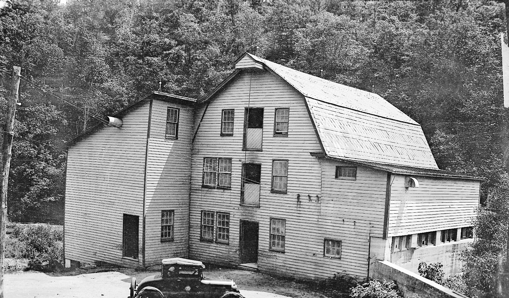
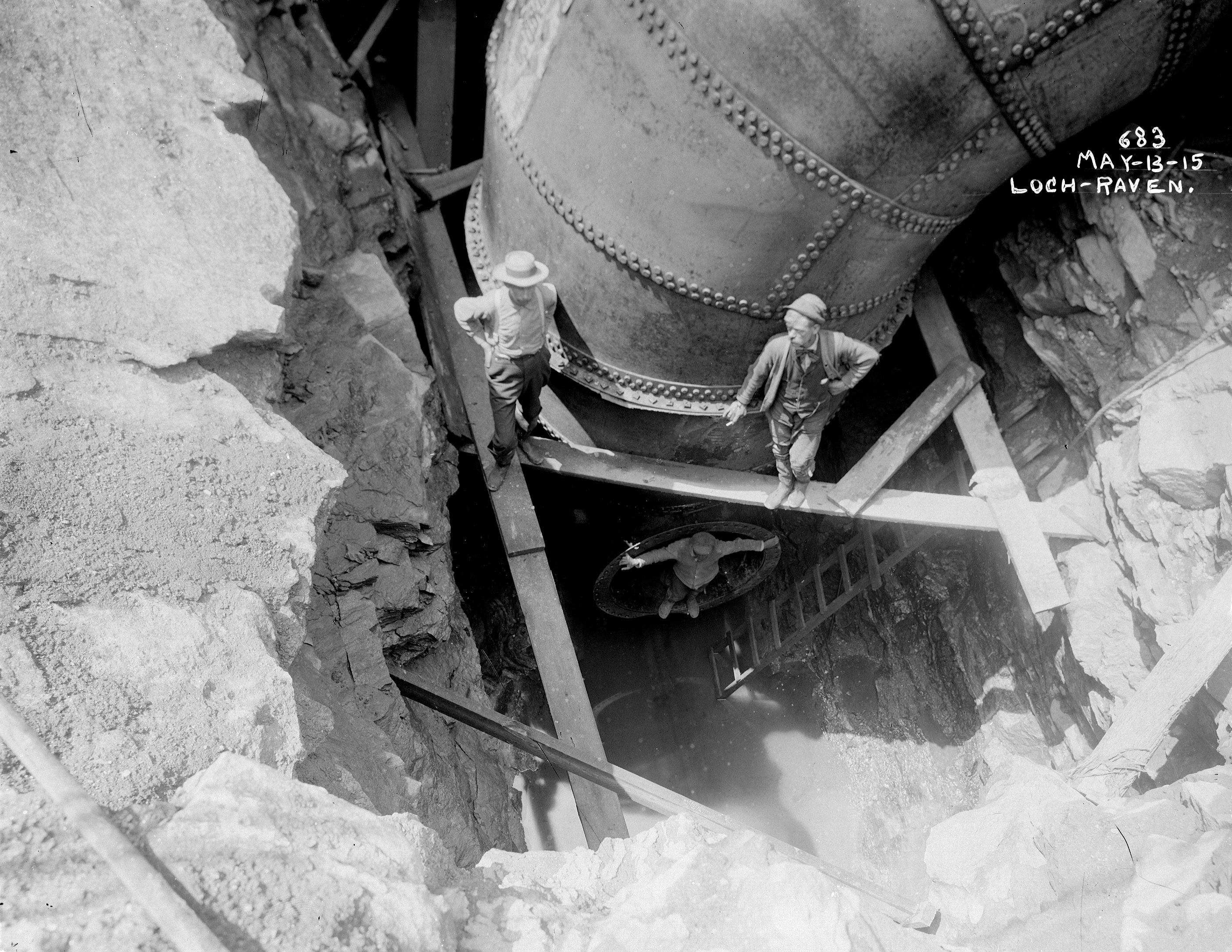
The below photo from the Public Works collection, which is the same as the one in the Hughes Collection, marked as #457 is described as –

LochRaven 8-14 457

Title [Metal bridge at Loch Raven, Baltimore]
Accession Number P75-54-0586g
Photographer Hughes Company
Date Created 1914-08-07
Caption From Sleeve: Greiner and Whitman Bridges. Loch Raven. (15370) -2 negs.
Loch Raven. Aug 7 14
Description Bridge attributed to John Edwin Greiner and Ezra B. Whitman.
Title Note Title supplied by cataloger.
Notes Positive digital file from original glass negative
Measurements 8 x 10 in.
DCMI Type StillImage
Work Type (AAT) photographs
Process black-and-white photographs, gelatin dry plate negatives
Genre documentary photography
Location United States — Maryland — Baltimore
Subject Names (Local) J.E. Greiner Company
Loch Raven Reservoir (Md.)
Subject Names (LCNAF) Greiner, J. E. (John Edwin), b. 1859
Subject (TGM) Truss bridges
Condition Border of black paper. Specks of emulsion chipped all over image. Glass side has fingertip smudges.
Collection Hughes Company Glass Negatives
Credit Line The Photography Collections, University of Maryland, Baltimore County
Rights This item may be protected under Title 17 of the U.S. Copyright Law. It is made available by UMBC for non-commercial research and education. For permission to publish or reproduce, please contact Special Collections at speccoll(at)umbc.edu.
Repository University of Maryland, Baltimore County (UMBC)

A couple things that jump out at me are these facts – Greiner and Whitman Bridges: These gentlemen (probably the ones in the photo) were the consulting engineers on the job. The actual builder of the bridge was the Roanoke Bridge Co. It also notes that there are two negatives? I have what I thought was the original negative. Did they photograph a print and make 2 negatives? Also, my plate is cracked and noted as such.

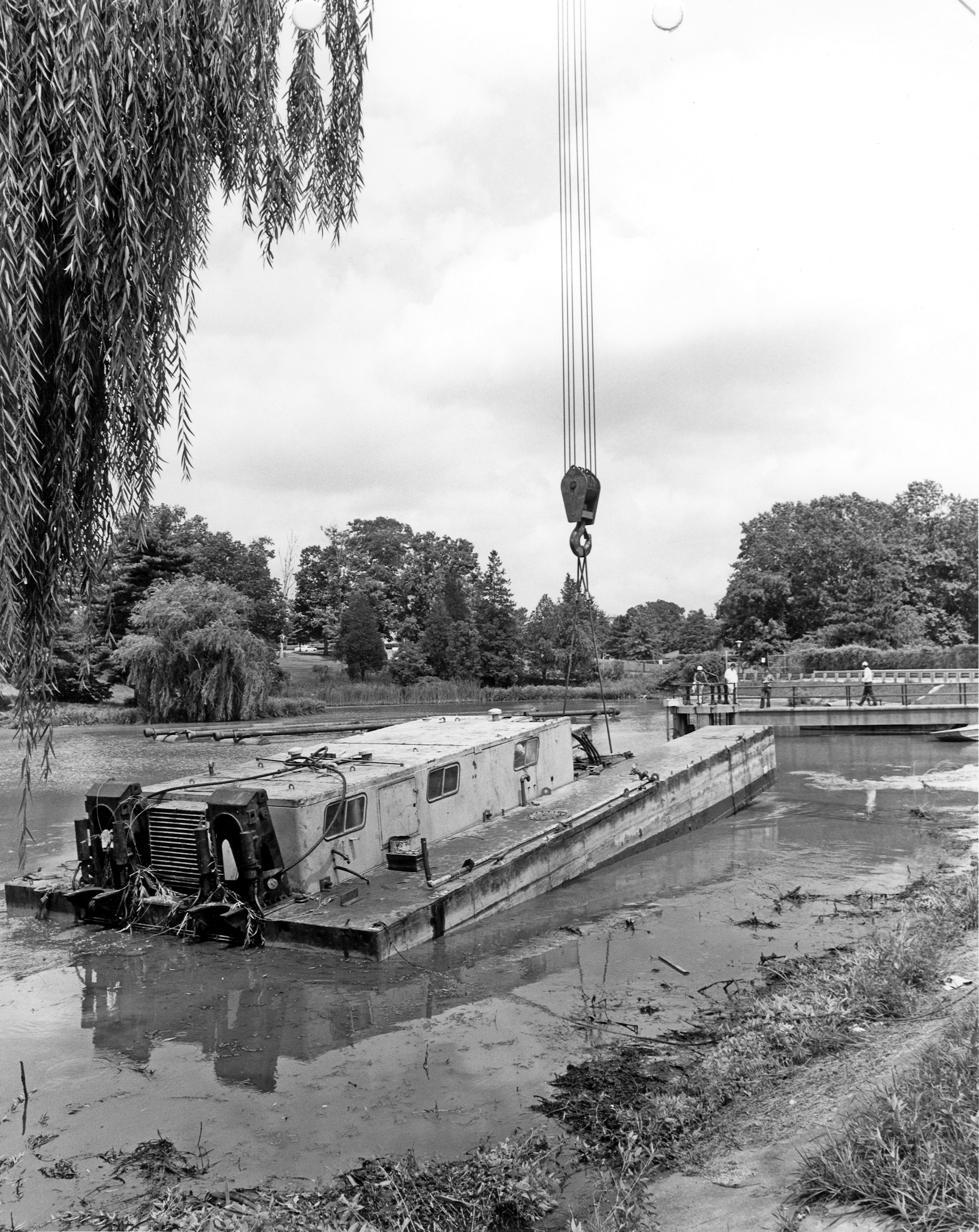
The photo below shows a side view, taken on the same date. The bridge was known as Bridge #1, also called the Yellott Bridge. It was approximately in the same place that the present bridge is – Loch Raven Drive.

LochRaven 8-14 455

Eden Mill Kayaking

14 Thursday Jul 2016

Posted by Ronald Parks in HISTORY, Photography, Reservoir, water history

≈ 3 Comments

Tags

eden mill, engineering, Hiking, HISTORY, kayaking, mills, Museum, Public Works, water history

Kathy and I went kayaking on one of the most peaceful creeks I know of – Eden Mill at Deer Creek. Back in July 2013 I posted about History and Photography, that people should appreciate the history of the mills and streams they hike. Since I have just started to kayak, I now have a deeper appreciation of the history of Eden Mill. The perspective is so much different on the water than it is walking the trails.

Additional research has shown that there were a few plans for damming Deer Creek. in July of 2013 I wrote that the crest of the proposed dam at the Rocks would be at an elevation of 540’. Another 1933 study put it at 430’. In either case, if the dam was built, the mill would be under water.

The below topography map shows the creek elevation at 342’. The dam is 16’ tall so that brings us to 358’. The mill is three stories so let’s add roughly another 36’ – that’s 394’. So yes, that is still a good 30 feet underwater! The mill is to the right of the word creek, just past the branch stream.

EM5

To know this and to understand the history makes it such a sweet kayaking adventure. Appreciate history. Go kayaking. Be happy!

EM7

Looking upstream from the base of the mill.

EM6

The Mill as it looked in the 1930s

EM1

The mill and top of dam. View from kayaks.

EM3

One of the branch streams that feeds Deer Creek. These two bridges would be under water.

EM4

View from under the bridge. Back in the 30s, this bridge was probably an old wooden one.

EM2

It doesn’t get any better than this!

Montebello Waste Lakes

05 Tuesday Jul 2016

Posted by Ronald Parks in Baltimore, water history

≈ Leave a comment

Tags

aerial, Baltimore, drone, engineering, FILTRATION, Health, HISTORY, Lake Montebello, maps, Montebello, POLITICS, Public Works, water, water history

Yes, there are two waste lakes at Montebello. The large one that people use every day as a park and a smaller one, hidden from view, on the filtration plant property. The large one was at one time (1881-1915) used as drinking water. The small one (1915) has always been used to settle out the waste by-products of the filtration process.

To the dismay of the Filter Engineer, he was forced to allow the Model Yacht Club to use the small lake for their club activities in the late 1930s. Sometimes when he was pissed off, he would drain the lake down. At the start of WWII, for security reasons, the club could no longer use the lake.

wl1939

wl1939b

Because of the amount of water processed and the waste created by this process, the lakes would need dredging. It was a lot easier to dredge the smaller one than to do the big one. Unfortunately, the dredged material would be pumped into the big lake. That one was to be dredged every 30 years. An optimal plan would be to dredge the small lake every five years.

wl1978

In 1978 thru 1984, the small lake was dredged.

wl1984

What was called a “sonic survey” took place in 1984, this was to show the nearby residents what needed to be done to the lakes. Both lakes were partially drained to show the amount of sludge build-up.

wl2003

This is a google map aerial of the lake in 2003. The brown sludge build-up is the overflow from the small lake. (Note that Google Map dates are not always correct)

wl2007

2005-2007 a portion of the small lake was dredged and a little over 1/3 of the big lake. Why? Money constraints. They should have completely dredged both lakes, but consulting engineers and politics dictates what goes on.

wl2010

By 2010 the small waste lake is practically filled, again (to the lower right of the 4 square basins) and it is now flowing into the large lake (Hard to see but it is in the lower right corner)

wl2015

By 2013 the big lake starts filling up rather quickly. The small lake is full

wl2016b

In 2016 it was decided to start dredging the small lake, only partially??

wl2016

The present day dredge cutting a path thru the sludge. The waste lake is about 30 feet deep here. they have only reached 17 feet (Photo courtesy Merrill Bros. drone)

What Baltimore Could Have Looked Like 1916

30 Thursday Jun 2016

Posted by Ronald Parks in Baltimore, HISTORY, water history

≈ Leave a comment

Tags

Baltimore, engineering, Geology, HISTORY, Jones Falls, maps, POLITICS, Public Works, water history

Here is a 1916 map of the Geological Survey showing the proposals of Senators Ogden and Campbell. They each had their own ideas on how Baltimore should look back then.

BaltiEnlarg1916r

I like how this map shows the reservoirs and the water supply conduits. Of interest to me is the reservoir at Philadelphia Rd. and the Mt Royal Reservoir. There was another Mt Royal one built in 1845. This new one received a name change for some reason.

1845 Original Mount Royal Reservoir:  Started construction of a new reservoir on the east side of Jones Falls above the Belvedere Bridge.

1846 Original Mount Royal Reservoir: The new reservoir replaced the old reservoir located on Calvert Street, and in addition, supplied water to the section of the City east of Jones Falls.  The new reservoir was 18 feet deep, with seven acres of water surface, and a capacity of 15 million gallons.  According to the Maryland Historical Trust Maryland Inventory of Historic Properties Form for the City of Baltimore, Loch Raven Dam, submitted to MHT 1-17-96, this 15 million gallon reservoir was also known as Mount Royal Reservoir.  This Mount Royal Reservoir was built near the location known in the year 1996 as Pennsylvania Station. By 1862, this Mount Royal Reservoir would be abandoned; and, the name of the Mount Royal Reservoir would be transferred to a new reservoir at a different location. (From early water history notes, R. Vann)

The Conduit from Loch Raven (aka my favorite workers GPN)

08 Wednesday Jun 2016

Posted by Ronald Parks in Baltimore, water history

≈ Leave a comment

Tags

Baltimore, engineering, glass plate negatives, Gunpowder Falls, HISTORY, Lake Montebello, photography, Public Works, water history

Since I started scanning and documenting the huge collection of Glass Plate Negatives (GPN) at work, there has always been a few that really caught my eye and became my favorites. Such being the one below. I would take the 8″ x 10″ GPN out of its falling apart sleeve, hold it up to the light and see what it was and in which collection it belonged. Most of these negatives were in the original boxes. Some not, just thrown into other boxes. I had to take a second look at this one. Is that a foot I see? I scanned it and blew it up and it sure does look like a foot! And a couple of workers taking a smoke break.

The original 1881 tunnel from the first dam to Lake Montebello was dug through rock. The new dam of 1915, just upstream from the old dam, was connected to the old tunnel by a steel conduit. The second picture below shows the steel conduit dropping down to meet the old one.

LochRaven 5-15 686a copy

I enlarged the center section and superimposed onto the corner.

LochRaven 5-15 683

Workers posing, which makes me wonder how much work would slow down if the cell phone/selfie was around back then?

Lime

24 Tuesday May 2016

Posted by Ronald Parks in Baltimore, Sewage History, water history

≈ Leave a comment

Tags

Baltimore, engineering, FILTRATION, Gunpowder Falls, Health, HISTORY, Lake Montebello, Montebello, Public Works, sewage, Sewage History, water, water history

As can be seen from the list below, Lime has been used as a disinfectant for many years as far as the sewerage system and health goes.

1865 – Board of Health: The general health account shows an expenditure of $2,918.11. This account includes the appropriation for enclosing the Eastern Potter’s Field, erecting a dead house &c. and that for lime and incidentals.

1866 – Board of Health: 11,000 oysters were thrown away (This was in response to a cholera epidemic where 9 of 10 cases were found from eating oysters). We have used lime, Ridgewood’s and Sim’s disinfectant, and carbolic acid freely in the alleys and sewers.

1880 – General Superintendent of Streets: Your instructions in reference to the free use of lime in all alleys, gutters, vacant lots and places where stagnant pools of water were to be found, have been faithfully carried out.

1886 – Health Department: Disinfection – There was distributed in the streets, lanes, and alleys six hundred and thirty-seven cart-loads of lime. In addition, the Department manufactured and distributed twenty-two (22) tons of disinfectants; the principal portion of which was used in sewers and inlets.

1888 – Assistant Health Commissioner’s Report – During the year six thousand and thirty-one (6031) cart loads of refuse were removed from sewers, inlets and covered gutters. Six hundred and ten loads of lime and twelve tons of carbolate of lime were distributed for the purposes of purification and disinfection.

Liming against Asiatic Cholera.

Lime1

In 1910 Baltimore used chloride of lime (along with calcium hypochlorite and intermittent applications of alum sulfate) as a disinfectant in the water supply. And in 1922 it was specifically used for corrosion control.

Mont 8-12 050

The above photo, from a previous post, was before the Montebello Filtration Plant was built. The water supply came from the Gunpowder River (7 miles away), directly to this gate house and emptied into the Montebello Lake.

As can be seen, too much lime is not a good thing.

Lime2

This is after about 10 years of lime application, under the clear-well at Plant 1 Montebello.

OLYMPUS DIGITAL CAMERA

And this is after about 20 years. No clear-well at Plant 2, this pipe goes directly to the reservoir. There is about a 6″ pipe overhead that drops lime directly into this conduit.

Harper’s Waste Weir

03 Tuesday May 2016

Posted by Ronald Parks in Baltimore, HISTORY, water history

≈ Leave a comment

Tags

Baltimore, engineering, FILTRATION, HISTORY, Jones Falls, Lake Roland, Public Works, water, water history

The Jones Falls became nothing more than an open cesspool that emptied into the Inner Harbor in the early 1800s. It was decided to build a reservoir upstream, outside of town and use conduit to carry drinking and fire fighting water to the public.

In 1858, work begins to increase the supply of water from the Jones Falls by building a dam. The reservoir to be created would be called Swann Lake, later to be renamed Lake Roland. A conduit would connect the reservoir to the Mount Royal Reservoir, and the water would flow by gravity through a 3-mile-long elliptical bricked tunnel. A Valve House was installed on top of the conduit and was originally known as the “Harper Waste Weir” (later to be referred to as “The Cross Keys Valve House”); and its construction would be completed in 1860. The Harper Waste Weir was located between Swann Lake and the Influent Gatehouse at the Hampden Reservoir. The Influent Gatehouse to the Hampden Reservoir pipe configuration was such that Swann Lake water could flow to the Mount Royal Reservoir or to the Hampden Reservoir. The Harper Waste Weir structure was one of three stone Greek Revival gatehouses to be built as part of the Baltimore’s City municipal water system along a conduit that would run from Swann Lake to Mount Royal Reservoir. The other two gatehouse structures (construction would be completed in 1862), being the effluent gatehouse at Swann Lake and the influent gatehouse to the Hampden Reservoir.

WasteWeir2

By doing this, the amount of natural water flow down the Jones Falls was impeded and this lack of flow created a worse  situation for Baltimore – the Jones Falls and the Harbor could not be flushed out on a regular basis (except during storms, which caused severe flooding).

WasteWeir

The structure on the left is the original Waste Weir. The wooden portion was built later to hold alum, which was added to the water by hand.

img009-392

This building still exists and has recently been added to Baltimore’s list of historic places.

img008-390

Montebello Lake

25 Monday Apr 2016

Posted by Ronald Parks in Baltimore, filtration, HISTORY, water history

≈ 1 Comment

Tags

Baltimore, engineering, FILTRATION, Health, HISTORY, Lake Montebello, Montebello, photography, Public Works, water, water history

Last week I received a request from my boss to check out the Montebello Lake. That it was reported that someone was seen dumping petroleum and chlorine into the lake. My first question was – “Did the person who spotted this call the police?” It is a crime to tamper with the water supply, let alone dump toxic chemicals into a lake on our property. This lake is no longer part of the city water supply system, other than being a settling basin for what goes on in the filtration plant. It is a by-product of filtration, waiting to settle out before flowing into Herring Run. Most people, even the neighbors don’t know this. They still believe the lake is drinking water. It hasn’t been drinking water since 1915.

I go and check out the lake but didn’t find anything amiss. (Not only do people NOT call the police, but after 35 years of being here, I learn to take those calls for lake problems with a grain of salt. Most are not true and unsubstantiated, but they do need to be checked out)

004

This is the view across the lake towards the gate house. The brown you see in the water is sludge build-up. This lake was dredged in 2005-2007, but the contractors only did a small portion of the smaller lake where most plant sludge is collected before flowing to this lake. That lake will soon be dredged. (It should be every 3-5 years, with the big lake not needing to be done for 30 years)

040 031 006

The ducks, turtles, fish and other wildlife all seem to be fine. No effects from a toxic dump here. I also did not see any dead growth on the grass which would indicate dumping.

tiffanyrThis is one of the original drawings from 1875 showing the lake being built over Tiffany Run, which dumps into Herring Run. The run was diverted into a tunnel from the gate house, lower left of lake then heads along, marked as drain conduit to Herring Run.

016

This is the original 1880s Tiffany Run drain. It has been relined a couple times since being built.

011

Channel from Tiffany drain to Herring Run. This is probably the best part of my job, other than historical research – getting to roam around in the woods. All 300 acres.

End Fluoride

07 Thursday Apr 2016

Posted by Ronald Parks in Baltimore, Fluoride, water history

≈ Leave a comment

Tags

Baltimore, engineering, FILTRATION, fluoride, Health, HISTORY, Montebello, POLITICS, Public Works, water history

In May 2008 the Mayor of Baltimore had a program called the “Innovation Bank” This was a program that allowed City Employees to make suggestions on how the City could save money. The winner could win up to $5,000.00 for their idea.

The first idea that popped into my mind was to end Fluoridation of the drinking water supply. Back then the over-all savings to the City would have been $670,000.00 a year. Today it is closer to one million a year. After about a month of waiting for a reply to my proposal, I called the Mayor’s Office and was told – “Yeah, she saw it” (Was that a snicker I heard in her assistant’s voice?)

Today I received an email from a woman who had started a campaign a couple years ago to end fluoridation of Baltimore’s Water. It said: Breaking news:  The resolution/bill to study water fluoridation is being introduced TODAY at the City Council meeting, in City Hall, 5pm.  You are all welcome to attend; however, there is no actual action taking place today except that the bill will be read off a list as being officially introduced.  Exciting!  And now: Its on.  Time to start prepping for a hearing about 6 weeks from now.

This is great news! I could list all the reasons WHY we should have stopped (or not started at all) but I will let the experts tell you. For me, my dislike for the poison came my first week on the job in 1981 when I was asked to work on the fluoride pumps and saw how the leaking acid ate thru the metal stand and concrete base. I thought to myself – this stuff can’t be good for you! You can read what the experts say here:

http://fluoridealert.org/

Below is a photograph showing when Baltimore first started using fluoride

Fluor 11-52

Tunnel Inspection

06 Wednesday Apr 2016

Posted by Ronald Parks in Baltimore, water history

≈ 1 Comment

Tags

Baltimore, engineering, FILTRATION, Gunpowder Falls, HISTORY, Jones Falls, Lake Montebello, Montebello, Public Works, tunnel, water, water history

Between the years 1875 and 1881 a tunnel, 12′ in diameter 7 miles long was constructed between a dam on the Gunpowder River and a man-made lake at Montebello. This was all part of the new, permanent water supply for Baltimore. It would eventually replace the supply from the Jones Falls. As needed, this tunnel was inspected and found to be in very good condition over the years. The majority of the tunnel is through solid rock with only a few sections having a brick lining. As the City grew, a new dam was built upstream in 1914, with a connection to the 1881 conduit.

In 1933 the City was contemplating a new source of water. The decision was made to build  a parallel tunnel from Loch Raven (on the Gunpowder Falls). An inspection by the consultants was made of the old tunnel first. The below photographs show what they found – rock falls and leakage.

The old tunnel was taken out of service and the new tunnel was used. In the 50s and 60s it was decided to re-use the old tunnel, which carried raw water, to start sending processed water to Baltimore County. An inspection of the tunnel, which at this point being only 5-1/2 miles long (Bulkheads built on each end of the tunnel that were no longer needed) was done in 1968. These consultants, pictured below, found more of the same. Rock falls and leaks. Three of these men I eventually worked with in 1981.

Another inspection was done in 1984. Unfortunately I can not find any photographs. I do have the reports from this inspection and it is not good. More rock falls and leakage. I was asked last year to be a part of a new inspection group to enter this tunnel. I immediately said yes! BUT, over the course of a couple months preparing for this and all the safety people you can imagine being involved, it was decided to send in a remote operated vehicle. Not sure when they will do this, I just know the sub isn’t big enough for me to fit into!

Two quotes came to mind when i was asked “Why do you want to go in there? It is dangerous!”

Valeria to Conan the Barbarian – “Do you want to live forever?” And Lenny and Ziggy singing “Death by Misadventure!”

← Older posts
Newer posts →

Blogroll

  • Flouride Action Network
  • lulu
  • My Book
  • WordPress.com
  • WordPress.org

Recent Posts

  • Bermuda 2023
  • ICELAND April 2023
  • George Chalmers of Fochabers
  • In Search of The Skipjack Ada Mae
  • Trap Pond Kayak

Blog at WordPress.com.

  • Subscribe Subscribed
    • Water and Me
    • Join 231 other subscribers
    • Already have a WordPress.com account? Log in now.
    • Water and Me
    • Subscribe Subscribed
    • Sign up
    • Log in
    • Report this content
    • View site in Reader
    • Manage subscriptions
    • Collapse this bar
 

Loading Comments...