• About
  • History Writings

Water and Me

Water and Me

Category Archives: HISTORY

Health Department 1936-1937

29 Thursday Sep 2016

Posted by Ronald Parks in Baltimore, Health, HISTORY

≈ Leave a comment

Tags

Baltimore, dentist, HISTORY, hospital, POLITICS, Public Works

Whenever I get a break from my normal job, checking on the contractors, I continue with my research and documentation of museum archives. Today I scanned a box of 5″ x 8″ photographs that had no markings or descriptions. I gave them my own, only so I know what is in the box. Each box comes with an electronic index after scanning.

hd013a

So this guy gets worked on, sitting on a wooden chair in what appears to be a closet.

hd013

And this person gets a nice dentist office. Hmmm…wonder why?

hd075

Nurses posing. One in back right looks a little psycho to me.

hd038

Nurses posing again, this time with patients. Two of which are posing themselves. Not sure what two nurses on right are doing?

hd070

A segregated ward no doubt. In my one book from 1935-1940 I mention about the blacks having a black doctor and the whites having a white one. For posing purposes I guess these guys get white ones (or was there no black doctors then at City Hospital?)

hd046

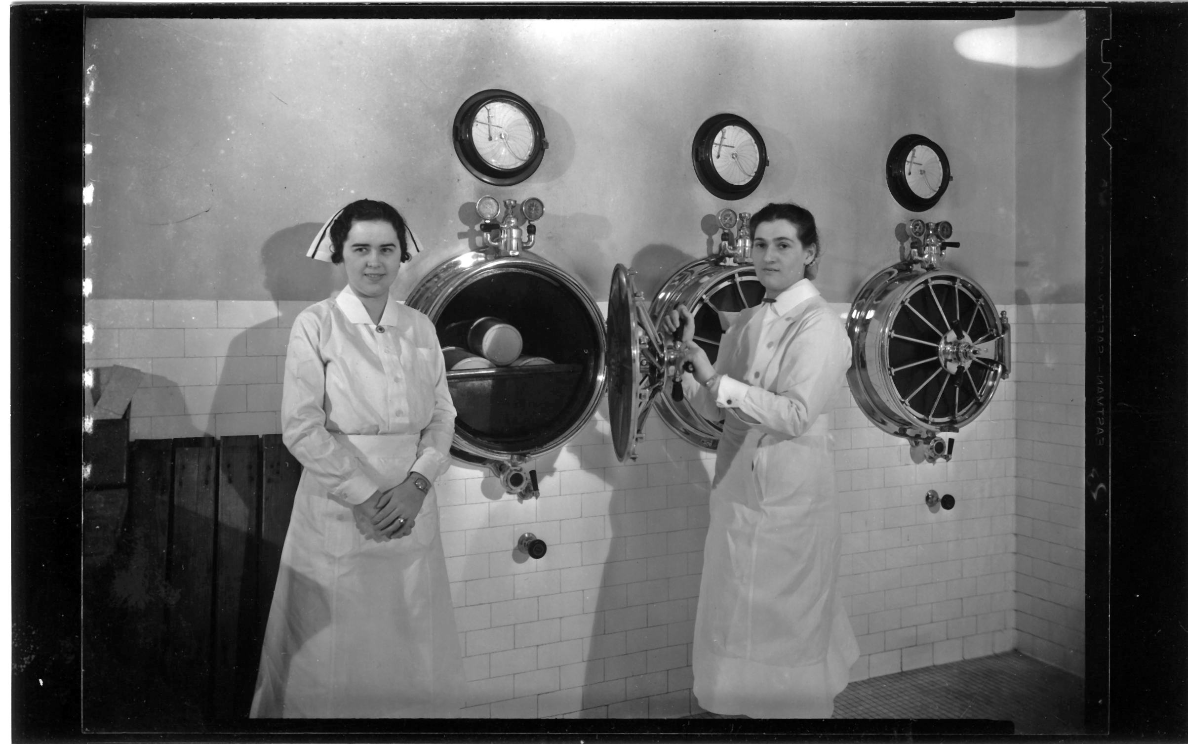
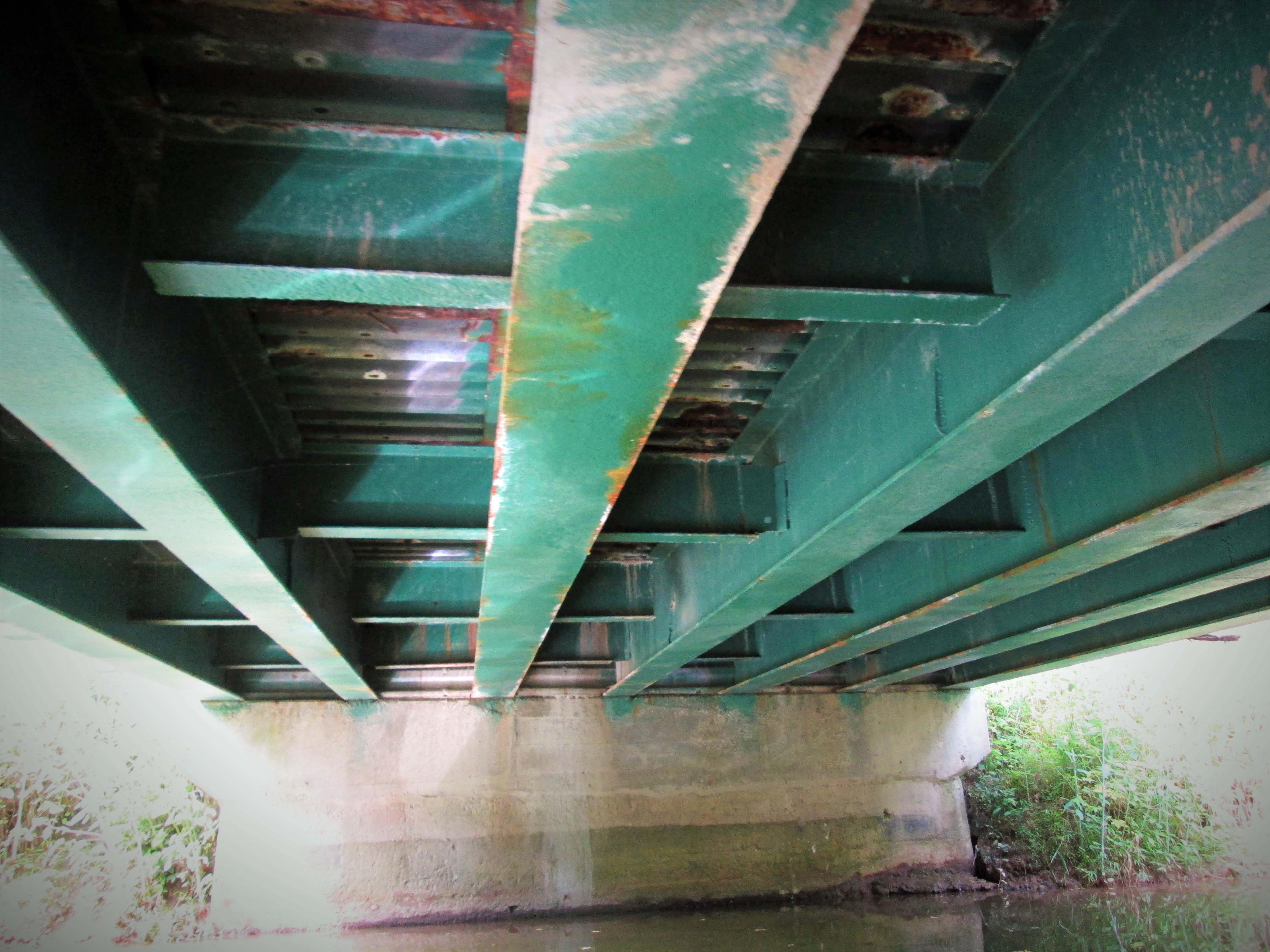
The only caption I could think to give this photo concerns torpedo tubes or pressure cookers??

hd029

I wonder what malady this person has/had, that needs this many doctors??

hd010

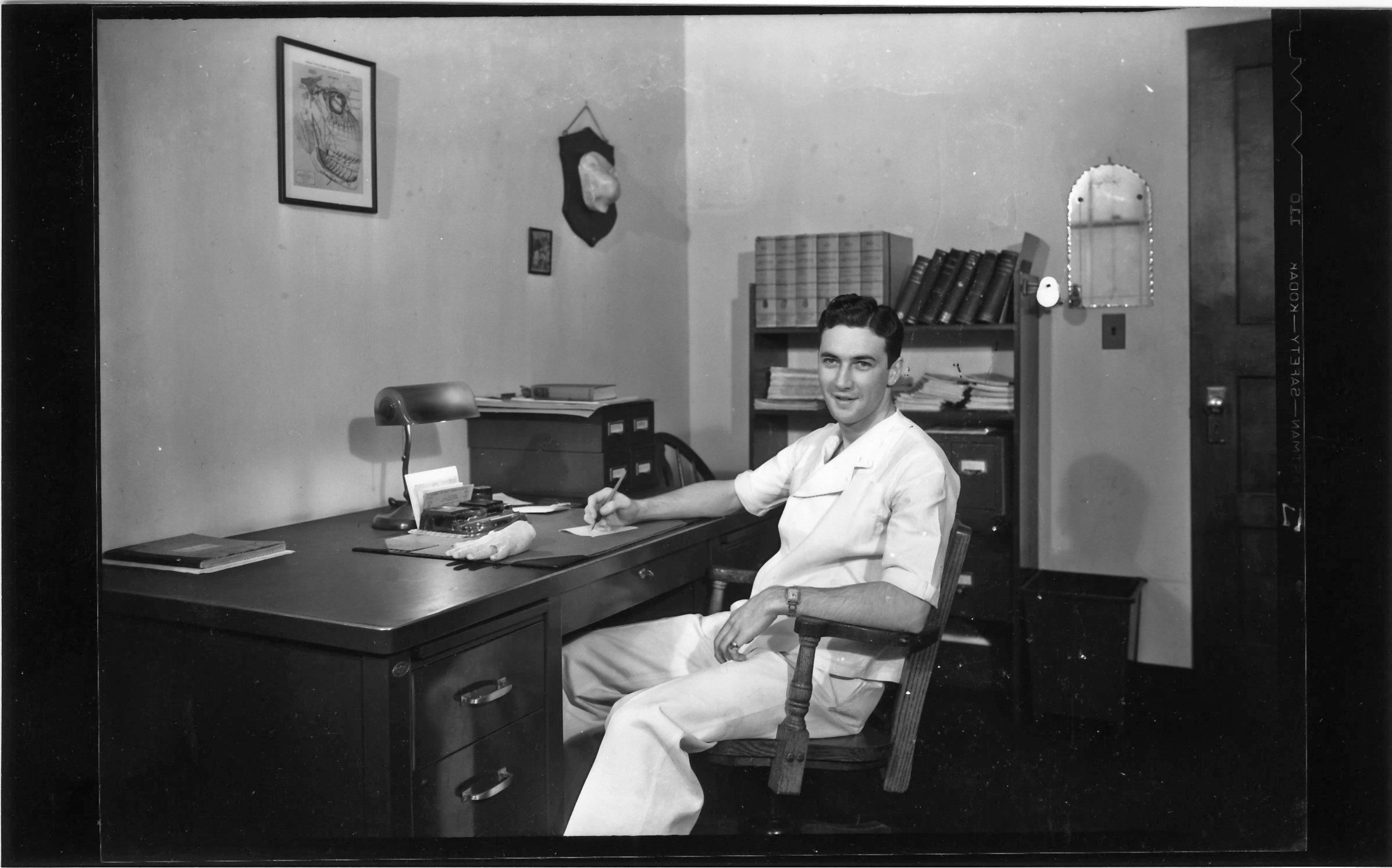
A little odd. A hand wearing a ring on the desk and what looks like a nose hanging on the wall??

hd009

Bureau of Liens. Poster asks that you pay your taxes promptly

Leakin Park

05 Monday Sep 2016

Posted by Ronald Parks in art, Baltimore, Hiking, HISTORY, Photography, water history

≈ 1 Comment

Tags

art, Baltimore, engineering, Hiking, HISTORY, Parks, photography, Public Works, sewage, Sewage History, water history

Visited this park the other day. Our plans for the Eastern Shore were cancelled by Hermine. It was a nice hike. Below is from the Baltimore Heritage website.

Crimea Estate at Leakin Park
By Johns Hopkins
The Crimea Estate is the former summer home of Thomas DeKay Winans, a chief engineer of the Russian Railway between Moscow and St. Petersburg in the 19th Century. The estate features Winans’ Italianate stone mansion, Orianda, as well as a gothic chapel, a “honeymoon” cottage, and a carriage house. The architectural design is said to have been inspired by Winans’ French-Russian wife, Celeste Louise Revillon.

An early, and now often overlooked, part of the estate is called Winans Meadow in Leakin Park. This current meadow was the site of an early milling operation along the Gwynns Falls River. An iron water wheel still remains that pumped water to the Orianda mansion. Along with the water wheel, a barn, silo, smokehouse, and root cellar also tell the story of early development in West Baltimore. There is even an intriguing battlement near the meadow that is thought to be modeled after the Battle of Balaklava where the Russian stand against the British was immortalized in Alfred Lord Tennyson’s poem “The Charge of the Light Brigade.”

Although Leakin Park has retained its original structures in a picturesque natural setting, it almost wasn’t so. In the 1970s, federal and city officials planned to route Interstate 70 through the park in front of the mansion and directly through the carriage house. Saved by a group of dedicated Baltimoreans, the estate remains a central element in Leakin Park. (Check Google Maps for this road – it ends right at the park. The road to nowhere)

Not mentioned in the above narrative is the fact that since 1940, 71 bodies have been found in the park. Dumping ground for west Baltimore knuckleheads. It is about 1200 acres large. Part of the Blair Witch Project was filmed here.

002

The chapel where annual herb festivals are held.

007

Part of the ‘Art in the Park’ collection. Mr Keebler’s house.

009

Sometimes nature creates her own art.

013Shrooms.

014

Clay art.

024

Big scary squirrel.

028

Spider-woman.

033

Nice little walkway to the next trail down.

044

Fort remnants.

047

Through the doorway, fireplace.

051

Windows to its soul.

054

Looks like a place to keep your black powder.

057

Interior of bunker.

069

The water wheel. It is unbelievable how far up the hill this had to pump water – to the mansion.

073

Water works. (I have to mention something about water since that is what my blog is supposed to be about) (It smelled like sewage here. I read that during the last storm, 850,000? gallons of sewage was dumped into the Gwynn’s Falls – controlled dump?)

083

Trails were marked pretty good.

090

Kathy and I stood and stared at this for a while. No clue. It is on cables and has a trap door with hooks. Torture item? Remnant from filming Blair Witch?

099Man made art…

108

Nature made art.

114

The old carriage house.

117

Pole dancing crab

118

Honeymoon cottage.

125

Art.

126

Mansion.

135

Nice.

Susquehanna revisited

28 Sunday Aug 2016

Posted by Ronald Parks in HISTORY, Photography, water history

≈ Leave a comment

Tags

Baltimore, engineering, Hiking, HISTORY, kayaking, light house, photography, Public Works, water history

Back in 2013 I wrote about the Susquehanna River. More specifically on the droughts and the need for Baltimore to withdraw water from the river. This is done through the intake structures above the Conowingo Dam.

During the research for my water history book, I read the various water engineering reports concerning the need for alternate water sources. The Susquehanna came up quite a few times. In one of the reports it was mentioned that there were 13 – 16 various sewage plants along the river. After the drought of 2010 and our using the Susquehanna River as a source of water, I decided to take a field trip to see this river.

I started in 2011 and it took a while to be able to hike and drive along the river. It is 444 miles long (Depending on who you ask), from Cooperstown NY to Havre de Grace Md. No, I did not walk and drive the whole way in one outing. I would drive to a town or just outside it, get out and start hiking for a few miles, up one side and down the other. I would head back to Baltimore then a couple weeks later, ride to the next town until I got far enough north, I just drove all the way to Cooperstown and started hiking/driving south. Climbing under bridges over train tracks and thru some strange parts of towns, hearing a variety of stories about the river. I visited such communities and areas as Goodyear Lake, Binghamton, Wilkes-Barre, Harrisburg, Three Mile Island, Columbia, Turkey Hill, etc.

I was going to do a photo-journal book about my travels but sometimes life gets in the way and I just never had a chance to finish the book. There are two excellent books on the Susquehanna that I wish I read before I started my travels – Susquehanna: River of Dreams and Down the Susquehanna to the Chesapeake.

Today, Kathy and I visited Havre de Grace. Always an adventure!

P1070273

Part of the Susquehanna Locks. While hiking through here years ago, I came across a lot of these, mostly hidden and grown over.

P1070275

Lock House – who has a key to the lock house?

P1070286

Rte 40 Hatem Bridge, old RR bridge and Interstate 95.

P1070288And yes, there is a boat – kayak ramp!

P1070296

Always alone, but never alone…

P1070299

This guys head just bobbed up and down with the ripples of tide

P1070302

Me: Oh look, an 1812 candle holder! Kathy: It’s a corn cob holder for the squirrels. I knew that!

P1070308 (2)

The pier.

P1070313

It a piers that part of the pier is missing.

P1070314

Concord Point lighthouse.

P1070315

Some history

P1070319 (2)

As many photographs that I have taken of this, I just always liked it in black and white

Dam Jam II

23 Tuesday Aug 2016

Posted by Ronald Parks in HISTORY, Reservoir, water history

≈ 8 Comments

Tags

Baltimore, engineering, FILTRATION, Gunpowder Falls, Hiking, HISTORY, Public Works, water history

Nice day for a hike thru Cromwell Valley Park. Always like listening to these guys speak on the history. Learn something new every time. The volunteers here are a great group of people who deserve a lot more credit than they get.

015

View from the observation deck on top of the dam. Water level is dropping again.

056

First stop was the restored lime kilns. Big difference since 2006. Nice turnout for a history talk.

079

The balancing reservoir. See last post for when it was still in use…

Clifton Gate House – new project

21 Thursday Jul 2016

Posted by Ronald Parks in Baltimore, HISTORY, Reservoir, water history

≈ Leave a comment

Tags

Baltimore, engineering, FILTRATION, Graves, HISTORY, Lake Clifton, POLITICS, Public Works, water, water history

There is a renewed interest in restoring the old Clifton Gate House. I have been invited to another meeting to determine what is to be done with it. I went to one of these meetings a while ago. A farmer wanted to turn it into a weekend farmers market. He said he had $10,000 he was willing to invest in repairs! That wouldn’t cover one small portion of the roof (Spanish tiles are expensive!) An interested party for this meeting is Civic Works. I hope they get the ok to take it over. They are currently restoring the Clifton Mansion in Clifton Park. Former estate of Johns Hopkins. It is a great project being done. I enjoy going on tours there.
The reservoir, piping and gate house were built between the years 1875 and 1888. The tunnel work between the Montebello Reservoir and the Clifton Estate commenced on August 16, 1876. In 1877 it was suggested to construct an additional lake at Clifton. In 1878 the Clifton Tunnel was completed and brick arched. The decision was made by the Water Board to go ahead and create an additional reservoir at Clifton. This work started in 1879. By 1881 the Lake Clifton construction was left unfinished due to lack of funds. The Clifton gate chamber was completed and a wooden shed is built over it to protect the iron work from the weather. Because of lack of funds, work halted on the lake and did not resume until 1884. (Water was sent to the City via the valves under the wooden shed)(Wish I could find a photo of that!)
Work at Lake Clifton progressed satisfactorily during 1887. The tunnel connecting Lake Clifton to Lake Montebello was in thorough working order. The gate-house superstructure is well under way. It is believed that it is advanced enough where water can be let into the Lake during the year 1888.
1888 – Lake Clifton is finally completed and put into service on December 27, 1888. Lake Clifton has a full capacity of 265 million gallons of water. The water area is 30 acres and is 30 feet deep and has the same elevation as Lake Montebello. (The completion stone for the gate house says 1887)

c3

From a postcard, soon after building.

c2

The lake (reservoir) in service and supplying water to the City.

c7

The completion stone 1887.

c1

Interior view a couple years ago.

c6

Neglected roof.

c4

The lake after being drained, to make room for a new school. Graves were found here.

c5

Clifton Mansion being restored by Civic Works. From up in the tower you can see the gate house and the outline of where the lake was.

Other People’s Digital Collections

18 Monday Jul 2016

Posted by Ronald Parks in Baltimore, HISTORY, water history

≈ Leave a comment

Tags

Baltimore, engineering, glass plate negatives, Gunpowder Falls, HISTORY, Public Works, water history

I learned quite a bit during my History Preservation classes. Most notably, concerning research. The instructor, Eli Pousson, showed us many resources where we could find information and photographs. So I went to one site at a local university (Hughes Collection) and as I normally do, I typed in two keywords in the search box. First, ‘Montebello’ followed by ‘Loch Raven’.  There were about 30 photographs listed, most of which were mislabeled or misleading.

The below photo from the Public Works collection, which is the same as the one in the Hughes Collection, marked as #457 is described as –

LochRaven 8-14 457

Title [Metal bridge at Loch Raven, Baltimore]
Accession Number P75-54-0586g
Photographer Hughes Company
Date Created 1914-08-07
Caption From Sleeve: Greiner and Whitman Bridges. Loch Raven. (15370) -2 negs.
Loch Raven. Aug 7 14
Description Bridge attributed to John Edwin Greiner and Ezra B. Whitman.
Title Note Title supplied by cataloger.
Notes Positive digital file from original glass negative
Measurements 8 x 10 in.
DCMI Type StillImage
Work Type (AAT) photographs
Process black-and-white photographs, gelatin dry plate negatives
Genre documentary photography
Location United States — Maryland — Baltimore
Subject Names (Local) J.E. Greiner Company
Loch Raven Reservoir (Md.)
Subject Names (LCNAF) Greiner, J. E. (John Edwin), b. 1859
Subject (TGM) Truss bridges
Condition Border of black paper. Specks of emulsion chipped all over image. Glass side has fingertip smudges.
Collection Hughes Company Glass Negatives
Credit Line The Photography Collections, University of Maryland, Baltimore County
Rights This item may be protected under Title 17 of the U.S. Copyright Law. It is made available by UMBC for non-commercial research and education. For permission to publish or reproduce, please contact Special Collections at speccoll(at)umbc.edu.
Repository University of Maryland, Baltimore County (UMBC)

A couple things that jump out at me are these facts – Greiner and Whitman Bridges: These gentlemen (probably the ones in the photo) were the consulting engineers on the job. The actual builder of the bridge was the Roanoke Bridge Co. It also notes that there are two negatives? I have what I thought was the original negative. Did they photograph a print and make 2 negatives? Also, my plate is cracked and noted as such.

The photo below shows a side view, taken on the same date. The bridge was known as Bridge #1, also called the Yellott Bridge. It was approximately in the same place that the present bridge is – Loch Raven Drive.

LochRaven 8-14 455

Eden Mill Kayaking

14 Thursday Jul 2016

Posted by Ronald Parks in HISTORY, Photography, Reservoir, water history

≈ 3 Comments

Tags

eden mill, engineering, Hiking, HISTORY, kayaking, mills, Museum, Public Works, water history

Kathy and I went kayaking on one of the most peaceful creeks I know of – Eden Mill at Deer Creek. Back in July 2013 I posted about History and Photography, that people should appreciate the history of the mills and streams they hike. Since I have just started to kayak, I now have a deeper appreciation of the history of Eden Mill. The perspective is so much different on the water than it is walking the trails.

Additional research has shown that there were a few plans for damming Deer Creek. in July of 2013 I wrote that the crest of the proposed dam at the Rocks would be at an elevation of 540’. Another 1933 study put it at 430’. In either case, if the dam was built, the mill would be under water.

The below topography map shows the creek elevation at 342’. The dam is 16’ tall so that brings us to 358’. The mill is three stories so let’s add roughly another 36’ – that’s 394’. So yes, that is still a good 30 feet underwater! The mill is to the right of the word creek, just past the branch stream.

EM5

To know this and to understand the history makes it such a sweet kayaking adventure. Appreciate history. Go kayaking. Be happy!

EM7

Looking upstream from the base of the mill.

EM6

The Mill as it looked in the 1930s

EM1

The mill and top of dam. View from kayaks.

EM3

One of the branch streams that feeds Deer Creek. These two bridges would be under water.

EM4

View from under the bridge. Back in the 30s, this bridge was probably an old wooden one.

EM2

It doesn’t get any better than this!

Graffiti as History

13 Wednesday Jul 2016

Posted by Ronald Parks in Baltimore, HISTORY

≈ 1 Comment

Tags

art, Baltimore, graffiti, HISTORY, Monuments, POLITICS, preservation, Statues

img013a

During last night’s class on Historic Preservation, the topic of graffiti came up for a brief moment. There is apparently two sets of graffiti inside the Washington Monument in downtown Baltimore. Those written in the base of the monument, dating back, possibly to the mid-1800s and that written in the tower, which was most recently done. There is an attempt to figure out and preserve the graffiti in the base, but yet, the graffiti in the tower is vulgar, obscene and must be removed! I posed this question to the group; wouldn’t the tower graffiti be historic in 100 years? A couple people were adamant that this type of graffiti is not historic.

So that got me thinking – who determines this? Who is to say what is vulgar and what is historic? A quick Google search of Roman Graffiti shows many sites with graffiti quotes that the Romans plastered everywhere. Did this graffiti tell a story of the social lives of people? Was Pompeii a den of iniquity? What about cave drawings? Supposed it was found out that these were all sexual in nature? Would they be removed? And petroglyphs? Rock carvings, some of which may be considered animal cruelty. Or are they the tales of various cultures?

I do not condone graffiti. I was once (when I was 17) considering writing a book about it while hitch hiking cross country. I was amazed at the different graffiti scribbled on the bathroom stalls of gas stations. Short stories and quotes about toilet paper (or the lack thereof) and where to get the best sex in town! Did this graffiti describe nomadic living? I’ve seen much graffiti that defaces public spaces and right next to it will be graffiti, renamed as a commissioned art piece. Who determines which of the two are really works of art? I’ve seen a lot of graffiti that were truly works of art. Someone I know went under a bridge, saw graffiti and did a painting of it. It was really good and I tried to buy her original artwork at auction but was outbid by many others.

Exploring Baltimore Heritage 101 Juxtapose

07 Thursday Jul 2016

Posted by Ronald Parks in Baltimore, HISTORY

≈ 1 Comment

Tags

Baltimore, HISTORY, Public Works, water history

For my class I was asked to do this – Hope it works!

This is the storeroom that was connected to the Eastern Pumping Station. They made fire hydrants and fittings here for the water department. The building is still there.

https://cdn.knightlab.com/libs/juxtapose/latest/embed/index.html?uid=0ccf28da-446d-11e6-8309-0e7075bba956

What Baltimore Could Have Looked Like 1916

30 Thursday Jun 2016

Posted by Ronald Parks in Baltimore, HISTORY, water history

≈ Leave a comment

Tags

Baltimore, engineering, Geology, HISTORY, Jones Falls, maps, POLITICS, Public Works, water history

Here is a 1916 map of the Geological Survey showing the proposals of Senators Ogden and Campbell. They each had their own ideas on how Baltimore should look back then.

BaltiEnlarg1916r

I like how this map shows the reservoirs and the water supply conduits. Of interest to me is the reservoir at Philadelphia Rd. and the Mt Royal Reservoir. There was another Mt Royal one built in 1845. This new one received a name change for some reason.

1845 Original Mount Royal Reservoir:  Started construction of a new reservoir on the east side of Jones Falls above the Belvedere Bridge.

1846 Original Mount Royal Reservoir: The new reservoir replaced the old reservoir located on Calvert Street, and in addition, supplied water to the section of the City east of Jones Falls.  The new reservoir was 18 feet deep, with seven acres of water surface, and a capacity of 15 million gallons.  According to the Maryland Historical Trust Maryland Inventory of Historic Properties Form for the City of Baltimore, Loch Raven Dam, submitted to MHT 1-17-96, this 15 million gallon reservoir was also known as Mount Royal Reservoir.  This Mount Royal Reservoir was built near the location known in the year 1996 as Pennsylvania Station. By 1862, this Mount Royal Reservoir would be abandoned; and, the name of the Mount Royal Reservoir would be transferred to a new reservoir at a different location. (From early water history notes, R. Vann)

← Older posts
Newer posts →

Blogroll

  • Flouride Action Network
  • lulu
  • My Book
  • WordPress.com
  • WordPress.org

Recent Posts

  • Bermuda 2023
  • ICELAND April 2023
  • George Chalmers of Fochabers
  • In Search of The Skipjack Ada Mae
  • Trap Pond Kayak

Blog at WordPress.com.

  • Subscribe Subscribed
    • Water and Me
    • Join 231 other subscribers
    • Already have a WordPress.com account? Log in now.
    • Water and Me
    • Subscribe Subscribed
    • Sign up
    • Log in
    • Report this content
    • View site in Reader
    • Manage subscriptions
    • Collapse this bar
 

Loading Comments...